

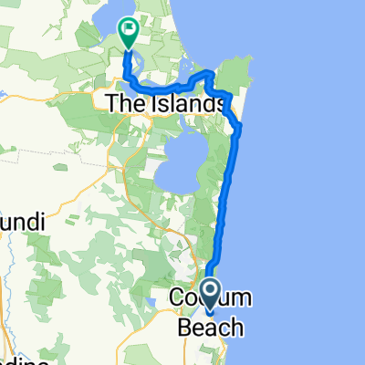
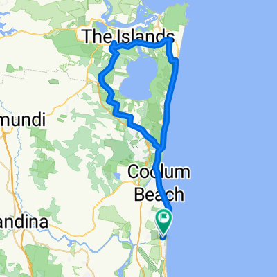
Coolum Beach to Maroochy Wetlands Sanctuary
A cycling route starting in Coolum Beach, Queensland, Australia.
Overview
About this route
Explore the breathtaking coastline and lush landscapes from Coolum to Maroochy Wetlands Sanctuary with our detailed e-bike route map. This map guides you through a scenic journey, highlighting the best bicycle pathways and key points of interest along the way. Note: There is a 2km section of roadside bicycle lane between Pacific Paradise and Bli Bli, providing a direct route. For a more scenic alternative, consider the route across Maroochy Bridge on cycle pathways, which extends the trip by an additional 6km, offering enhanced views and a more leisurely ride.
- 1 h 21 min
- Duration
- 22.5 km
- Distance
- 105 m
- Ascent
- 101 m
- Descent
- 16.7 km/h
- Avg. speed
- 52 m
- Max. altitude

Route quality
Waytypes & surfaces along the route
Waytypes
Cycleway
18.7 km
(83 %)
Quiet road
1.6 km
(7 %)
Surfaces
Paved
16.5 km
(73 %)
Unpaved
0.2 km
(1 %)
Concrete
12.6 km
(56 %)
Asphalt
2.9 km
(13 %)
Continue with Bikemap
Use, edit, or download this cycling route
You would like to ride Coolum Beach to Maroochy Wetlands Sanctuary or customize it for your own trip? Here is what you can do with this Bikemap route:
Free features
- Save this route as favorite or in collections
- Copy & plan your own version of this route
- Sync your route with Garmin or Wahoo
Premium features
Free trial for 3 days, or one-time payment. More about Bikemap Premium.
- Navigate this route on iOS & Android
- Export a GPX / KML file of this route
- Create your custom printout (try it for free)
- Download this route for offline navigation
Discover more Premium features.
Get Bikemap PremiumFrom our community
Other popular routes starting in Coolum Beach
 Coolum Beach - Tewantin
- Distance
- 27.8 km
- Ascent
- 194 m
- Descent
- 198 m
- Location
- Coolum Beach, Queensland, Australia
 Lake Weiba loop
- Distance
- 53 km
- Ascent
- 415 m
- Descent
- 413 m
- Location
- Coolum Beach, Queensland, Australia
 David Low Way, Coolum Beach to 82 Shorehaven Dr, Noosaville
- Distance
- 19.3 km
- Ascent
- 142 m
- Descent
- 145 m
- Location
- Coolum Beach, Queensland, Australia
 Marcoola to Noosa
- Distance
- 20.9 km
- Ascent
- 199 m
- Descent
- 166 m
- Location
- Coolum Beach, Queensland, Australia
 Coolum Beach to 113 Shorehaven Dr, Noosaville
- Distance
- 21.5 km
- Ascent
- 144 m
- Descent
- 152 m
- Location
- Coolum Beach, Queensland, Australia
 State Route to Petrie Ave at Marcoola
- Distance
- 8.1 km
- Ascent
- 86 m
- Descent
- 94 m
- Location
- Coolum Beach, Queensland, Australia
 tickle park option 2
- Distance
- 31.5 km
- Ascent
- 138 m
- Descent
- 121 m
- Location
- Coolum Beach, Queensland, Australia
 Merchants Parade 18, Marcoola to Merchants Parade 18, Marcoola
- Distance
- 22.9 km
- Ascent
- 88 m
- Descent
- 131 m
- Location
- Coolum Beach, Queensland, Australia
Open it in the app