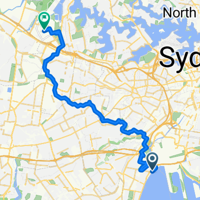
Cook Park Path, Kyeemagh to Sydney Olympic Park
A cycling route starting in Brighton-Le-Sands, New South Wales, Australia.
Overview
About this route
- 1 h 42 min
- Duration
- 26.7 km
- Distance
- 141 m
- Ascent
- 130 m
- Descent
- 15.7 km/h
- Avg. speed
- 36 m
- Max. altitude
Route quality
Waytypes & surfaces along the route
Waytypes
Cycleway
20.1 km
(75 %)
Quiet road
2.4 km
(9 %)
Surfaces
Paved
24 km
(90 %)
Concrete
10.8 km
(40 %)
Paved (undefined)
6.1 km
(23 %)
Continue with Bikemap
Use, edit, or download this cycling route
You would like to ride Cook Park Path, Kyeemagh to Sydney Olympic Park or customize it for your own trip? Here is what you can do with this Bikemap route:
Free features
- Save this route as favorite or in collections
- Copy & plan your own version of this route
- Sync your route with Garmin or Wahoo
Premium features
Free trial for 3 days, or one-time payment. More about Bikemap Premium.
- Navigate this route on iOS & Android
- Export a GPX / KML file of this route
- Create your custom printout (try it for free)
- Download this route for offline navigation
Discover more Premium features.
Get Bikemap PremiumFrom our community
Other popular routes starting in Brighton-Le-Sands
- The Grand Parade, Brighton-Le-Sands to 13-17 Coast Avenue, Cronulla
- Distance
- 16.6 km
- Ascent
- 0 m
- Descent
- 6 m
- Location
- Brighton-Le-Sands, New South Wales, Australia
- Brighton-Le-sands to Sydney Olympic Park
- Distance
- 26.7 km
- Ascent
- 89 m
- Descent
- 77 m
- Location
- Brighton-Le-Sands, New South Wales, Australia
- Cook Park Path, Kyeemagh to Sydney Olympic Park
- Distance
- 26.7 km
- Ascent
- 141 m
- Descent
- 130 m
- Location
- Brighton-Le-Sands, New South Wales, Australia
- (Map 2) The Laneways of Kogarah
- Distance
- 2.2 km
- Ascent
- 7 m
- Descent
- 8 m
- Location
- Brighton-Le-Sands, New South Wales, Australia
- 1A Roslyn Avenue, Brighton-Le-Sands to 1A Roslyn Avenue, Brighton-Le-Sands
- Distance
- 13.3 km
- Ascent
- 9 m
- Descent
- 17 m
- Location
- Brighton-Le-Sands, New South Wales, Australia
- Morning Rides - Flats
- Distance
- 13.4 km
- Ascent
- 42 m
- Descent
- 42 m
- Location
- Brighton-Le-Sands, New South Wales, Australia
- 2 Roslyn Avenue, Brighton-Le-Sands to 1A Roslyn Avenue, Brighton-Le-Sands
- Distance
- 12.2 km
- Ascent
- 3 m
- Descent
- 10 m
- Location
- Brighton-Le-Sands, New South Wales, Australia
- Cook Park Trail, Brighton-Le-Sands to Spark Lane, Wolli Creek
- Distance
- 7.6 km
- Ascent
- 3 m
- Descent
- 6 m
- Location
- Brighton-Le-Sands, New South Wales, Australia
Open it in the app