

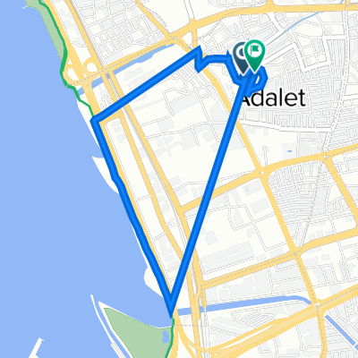
2109. Sk. 114, Bayrakli to Mithatpasa Cd. 56/01, Balcova
A cycling route starting in Bayraklı, İzmir Province, Republic of Türkiye.
Overview
About this route
- 1 h 45 min
- Duration
- 22.2 km
- Distance
- 86 m
- Ascent
- 120 m
- Descent
- 12.7 km/h
- Avg. speed
- 74 m
- Max. altitude

Route photos


Continue with Bikemap
Use, edit, or download this cycling route
You would like to ride 2109. Sk. 114, Bayrakli to Mithatpasa Cd. 56/01, Balcova or customize it for your own trip? Here is what you can do with this Bikemap route:
Free features
- Save this route as favorite or in collections
- Copy & plan your own version of this route
- Sync your route with Garmin or Wahoo
Premium features
Free trial for 3 days, or one-time payment. More about Bikemap Premium.
- Navigate this route on iOS & Android
- Export a GPX / KML file of this route
- Create your custom printout (try it for free)
- Download this route for offline navigation
Discover more Premium features.
Get Bikemap PremiumFrom our community
Other popular routes starting in Bayraklı
 iş ev
iş ev- Distance
- 12.3 km
- Ascent
- 91 m
- Descent
- 38 m
- Location
- Bayraklı, İzmir Province, Republic of Türkiye
 Izmir Kuzey Kordon
- Distance
- 21.4 km
- Ascent
- 48 m
- Descent
- 47 m
- Location
- Bayraklı, İzmir Province, Republic of Türkiye
 Bayraklı-a short trip
- Distance
- 12.5 km
- Ascent
- 188 m
- Descent
- 142 m
- Location
- Bayraklı, İzmir Province, Republic of Türkiye
 2109. Sk. 114, Bayrakli to Mithatpasa Cd. 56/01, Balcova
- Distance
- 22.2 km
- Ascent
- 86 m
- Descent
- 120 m
- Location
- Bayraklı, İzmir Province, Republic of Türkiye
 İzmir - Manisa Üçpınar - Menemen - İzmir
- Distance
- 117.7 km
- Ascent
- 730 m
- Descent
- 730 m
- Location
- Bayraklı, İzmir Province, Republic of Türkiye
 1586/16. Sokak 9/a to 2132/2 Sokak 13
- Distance
- 4.5 km
- Ascent
- 9 m
- Descent
- 11 m
- Location
- Bayraklı, İzmir Province, Republic of Türkiye
 Yerebatan Caddesi to Civcili Ahmet Ağa Meydanı
- Distance
- 507.9 km
- Ascent
- 5,639 m
- Descent
- 5,638 m
- Location
- Bayraklı, İzmir Province, Republic of Türkiye
 Izmir-Fethiye-Kas-Antalya
- Distance
- 801.9 km
- Ascent
- 11,077 m
- Descent
- 11,027 m
- Location
- Bayraklı, İzmir Province, Republic of Türkiye
Open it in the app