

Lodève to La Loubière, Combret
A cycling route starting in Lodève, Occitanie, France.
Overview
About this route
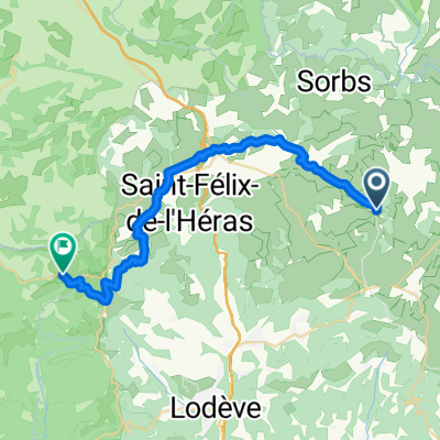
This was a challenging ride with plenty of climbing on mostly low and zero traffic roads. This was late October 2024 and we had fog and some rain, especially on the descent after the Col du Perthus. A bit chilly.
The first major climb was at a pretty steady grade for the entire ride. I think the second climb was similar, though my memory is a little fuzzy on it. The last major climb from Combret to La Loubière felt absolutely never ending. And with our heavy panniers at the end of a long day, it was indeed slow. Also, as we were nearing sunset and the road was wandering sometimes west and sometimes south, the sun was too often directly in our eyes. A tough climb to end our day.
We highly recommend these roads.
As is evident, late in the ride, we went straight when we should have made a turn. That added several kilometers to the ride.
- 10 h 11 min
- Duration
- 89.4 km
- Distance
- 1,799 m
- Ascent
- 1,408 m
- Descent
- 8.8 km/h
- Avg. speed
- 830 m
- Max. altitude

Route photos


Route quality
Waytypes & surfaces along the route
Waytypes
Road
29.5 km
(33 %)
Quiet road
11.6 km
(13 %)
Surfaces
Paved
35.8 km
(40 %)
Asphalt
35.8 km
(40 %)
Undefined
53.6 km
(60 %)
Continue with Bikemap
Use, edit, or download this cycling route
You would like to ride Lodève to La Loubière, Combret or customize it for your own trip? Here is what you can do with this Bikemap route:
Free features
- Save this route as favorite or in collections
- Copy & plan your own version of this route
- Split it into stages to create a multi-day tour
- Sync your route with Garmin or Wahoo
Premium features
Free trial for 3 days, or one-time payment. More about Bikemap Premium.
- Navigate this route on iOS & Android
- Export a GPX / KML file of this route
- Create your custom printout (try it for free)
- Download this route for offline navigation
Discover more Premium features.
Get Bikemap PremiumFrom our community
Other popular routes starting in Lodève
 2021 D 142 Runde bis Mas Gauzin
- Distance
- 11.5 km
- Ascent
- 182 m
- Descent
- 150 m
- Location
- Lodève, Occitanie, France
 Hérault 2010 - 05
- Distance
- 51.1 km
- Ascent
- 910 m
- Descent
- 906 m
- Location
- Lodève, Occitanie, France
 Lodève to La Loubière, Combret
- Distance
- 89.4 km
- Ascent
- 1,799 m
- Descent
- 1,408 m
- Location
- Lodève, Occitanie, France
 2016 Ride Day 60 - Lodève to Sauve
- Distance
- 103.5 km
- Ascent
- 903 m
- Descent
- 982 m
- Location
- Lodève, Occitanie, France
 Etape 09 – De Roqueredonde au Col de Roube
- Distance
- 21.2 km
- Ascent
- 534 m
- Descent
- 783 m
- Location
- Lodève, Occitanie, France
 Herault Runde
- Distance
- 31.3 km
- Ascent
- 451 m
- Descent
- 450 m
- Location
- Lodève, Occitanie, France
 fozieres
- Distance
- 19.1 km
- Ascent
- 310 m
- Descent
- 310 m
- Location
- Lodève, Occitanie, France
 Etape 08 – De La Vernède à Roqueredonde
- Distance
- 30 km
- Ascent
- 510 m
- Descent
- 521 m
- Location
- Lodève, Occitanie, France
Open it in the app