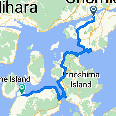
Day 567-2
A cycling route starting in Onomichi, Hiroshima, Japan.
Overview
About this route
- -:--
- Duration
- 1.2 km
- Distance
- 3 m
- Ascent
- 0 m
- Descent
- ---
- Avg. speed
- 6 m
- Max. altitude
Continue with Bikemap
Use, edit, or download this cycling route
You would like to ride Day 567-2 or customize it for your own trip? Here is what you can do with this Bikemap route:
Free features
- Save this route as favorite or in collections
- Copy & plan your own version of this route
- Sync your route with Garmin or Wahoo
Premium features
Free trial for 3 days, or one-time payment. More about Bikemap Premium.
- Navigate this route on iOS & Android
- Export a GPX / KML file of this route
- Create your custom printout (try it for free)
- Download this route for offline navigation
Discover more Premium features.
Get Bikemap PremiumFrom our community
Other popular routes starting in Onomichi
- Onomichi bike trip
- Distance
- 144.8 km
- Ascent
- 586 m
- Descent
- 587 m
- Location
- Onomichi, Hiroshima, Japan
- Shimanami Grand Tour
- Distance
- 280.3 km
- Ascent
- 400 m
- Descent
- 400 m
- Location
- Onomichi, Hiroshima, Japan
- Imabari
- Distance
- 76.8 km
- Ascent
- 432 m
- Descent
- 433 m
- Location
- Onomichi, Hiroshima, Japan
- 14 Apr D2 - 48K
- Distance
- 47.7 km
- Ascent
- 255 m
- Descent
- 191 m
- Location
- Onomichi, Hiroshima, Japan
- Lengthy bike tour from 尾道市 to 今治市
- Distance
- 62 km
- Ascent
- 563 m
- Descent
- 501 m
- Location
- Onomichi, Hiroshima, Japan
- Route to Setodachokone, Onomichi
- Distance
- 35.2 km
- Ascent
- 753 m
- Descent
- 749 m
- Location
- Onomichi, Hiroshima, Japan
- Length of Japan Onomichi to Takamatsu vs 2
- Distance
- 217 km
- Ascent
- 1,852 m
- Descent
- 1,851 m
- Location
- Onomichi, Hiroshima, Japan
- onomichi to imabari
- Distance
- 57.5 km
- Ascent
- 661 m
- Descent
- 639 m
- Location
- Onomichi, Hiroshima, Japan
Open it in the app