
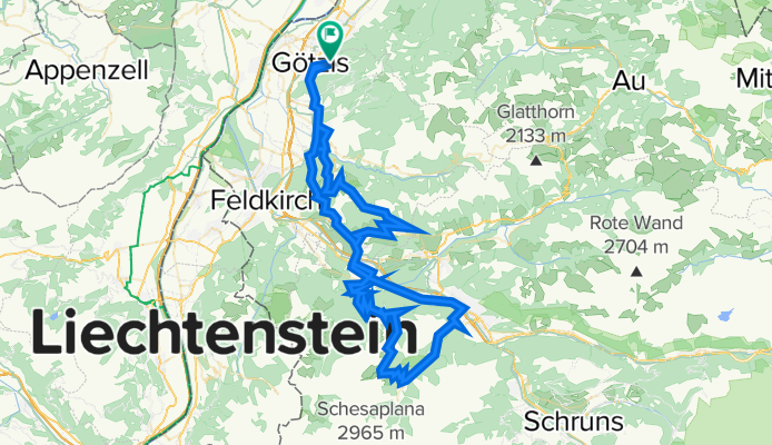
Götzis - Übersaxen - Düns - Nenzing - Furklaalpe - Brand - Bludenz - Nenzing - Götzis
A cycling route starting in Altach, Vorarlberg, Austria.
Overview
About this route
- -:--
- Duration
- 99.6 km
- Distance
- 2,138 m
- Ascent
- 2,138 m
- Descent
- ---
- Avg. speed
- ---
- Max. altitude

Continue with Bikemap
Use, edit, or download this cycling route
You would like to ride Götzis - Übersaxen - Düns - Nenzing - Furklaalpe - Brand - Bludenz - Nenzing - Götzis or customize it for your own trip? Here is what you can do with this Bikemap route:
Free features
- Save this route as favorite or in collections
- Copy & plan your own version of this route
- Split it into stages to create a multi-day tour
- Sync your route with Garmin or Wahoo
Premium features
Free trial for 3 days, or one-time payment. More about Bikemap Premium.
- Navigate this route on iOS & Android
- Export a GPX / KML file of this route
- Create your custom printout (try it for free)
- Download this route for offline navigation
Discover more Premium features.
Get Bikemap PremiumFrom our community
Other popular routes starting in Altach
 Götzis - Hoher Kasten - Hohe Kugel - Götzis
- Distance
- 86.3 km
- Ascent
- 2,561 m
- Descent
- 2,561 m
- Location
- Altach, Vorarlberg, Austria
 Sandholzerstraße to Sandholzerstraße
- Distance
- 23.7 km
- Ascent
- 54 m
- Descent
- 103 m
- Location
- Altach, Vorarlberg, Austria
 Berkmannweg to Sandholzerstraße
- Distance
- 19.3 km
- Ascent
- 49 m
- Descent
- 100 m
- Location
- Altach, Vorarlberg, Austria
 Götzis - Gapfohl - Alpweg Kopf - Dafins - Masella - Röthis - Viktorsberg - Letze - Orsanka - Maisaß - Schwimmersboden - Lugtrail
- Distance
- 70.2 km
- Ascent
- 2,714 m
- Descent
- 2,713 m
- Location
- Altach, Vorarlberg, Austria
 4th Big One
- Distance
- 88.3 km
- Ascent
- 2,791 m
- Descent
- 2,790 m
- Location
- Altach, Vorarlberg, Austria
 Altach - Gsohl
- Distance
- 17.9 km
- Ascent
- 572 m
- Descent
- 575 m
- Location
- Altach, Vorarlberg, Austria
 Dornbirner Höhenweg - Buch 60 km - 650hm
- Distance
- 58.9 km
- Ascent
- 466 m
- Descent
- 468 m
- Location
- Altach, Vorarlberg, Austria
 Trainigstour 1 MTB Marathon - 64km - 1534 hm
- Distance
- 66.4 km
- Ascent
- 1,395 m
- Descent
- 1,446 m
- Location
- Altach, Vorarlberg, Austria
Open it in the app