

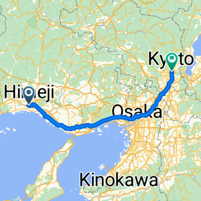
Day 573
A cycling route starting in Himeji, Hyōgo, Japan.
Overview
About this route
- -:--
- Duration
- 55.2 km
- Distance
- 60 m
- Ascent
- 74 m
- Descent
- ---
- Avg. speed
- 41 m
- Max. altitude

Continue with Bikemap
Use, edit, or download this cycling route
You would like to ride Day 573 or customize it for your own trip? Here is what you can do with this Bikemap route:
Free features
- Save this route as favorite or in collections
- Copy & plan your own version of this route
- Sync your route with Garmin or Wahoo
Premium features
Free trial for 3 days, or one-time payment. More about Bikemap Premium.
- Navigate this route on iOS & Android
- Export a GPX / KML file of this route
- Create your custom printout (try it for free)
- Download this route for offline navigation
Discover more Premium features.
Get Bikemap PremiumFrom our community
Other popular routes starting in Himeji
 kyoto
kyoto- Distance
- 118.7 km
- Ascent
- 993 m
- Descent
- 977 m
- Location
- Himeji, Hyōgo, Japan
 3丁目 8, 姫路市 to 姫路市
- Distance
- 15.4 km
- Ascent
- 91 m
- Descent
- 96 m
- Location
- Himeji, Hyōgo, Japan
 Himeiji osaka
- Distance
- 98.9 km
- Ascent
- 278 m
- Descent
- 292 m
- Location
- Himeji, Hyōgo, Japan
 Segment5-Greenway
- Distance
- 193.8 km
- Ascent
- 1,126 m
- Descent
- 1,117 m
- Location
- Himeji, Hyōgo, Japan
 銀の馬車道周遊ルート
- Distance
- 106.6 km
- Ascent
- 0 m
- Descent
- 0 m
- Location
- Himeji, Hyōgo, Japan
 Day 573
- Distance
- 55.2 km
- Ascent
- 60 m
- Descent
- 74 m
- Location
- Himeji, Hyōgo, Japan
 Recovered Route
- Distance
- 84.5 km
- Ascent
- 0 m
- Descent
- 4 m
- Location
- Himeji, Hyōgo, Japan
 Himeji to Kyoto
- Distance
- 139.7 km
- Ascent
- 292 m
- Descent
- 253 m
- Location
- Himeji, Hyōgo, Japan
Open it in the app