STARVED ROCK RIVER CENTURY
A cycling route starting in Channahon, Illinois, United States of America.
Overview
About this route
105 MILES ILLINOIS RIVER RIDE. BEAUTIFUL RIDE ALONG THE HISTORIC RIVER THAT JOLIET AND MARQUETTE USED TO FIND PASSAGE TO LAKE MICHIGAN IN THE 1600's.Â
START AT A REST STOP WITH PARKING NEAR CHANNAHON BY THE I & M CANAL. RIDE WEST PAST STARVED ROCK AND THEN BACK EAST ON THE NORTH SIDE OF THE RIVER ENJOYING TAIL WINDS.
- -:--
- Duration
- 169.2 km
- Distance
- 278 m
- Ascent
- 278 m
- Descent
- ---
- Avg. speed
- ---
- Avg. speed
Continue with Bikemap
Use, edit, or download this cycling route
You would like to ride STARVED ROCK RIVER CENTURY or customize it for your own trip? Here is what you can do with this Bikemap route:
Free features
- Save this route as favorite or in collections
- Copy & plan your own version of this route
- Sync your route with Garmin or Wahoo
Premium features
Free trial for 3 days, or one-time payment. More about Bikemap Premium.
- Navigate this route on iOS & Android
- Export a GPX / KML file of this route
- Create your custom printout (try it for free)
- Download this route for offline navigation
Discover more Premium features.
Get Bikemap PremiumFrom our community
Other popular routes starting in Channahon
- 24150 S Ford Rd, Channahon to 24064 S Lakeview Dr, Minooka
- Distance
- 11.4 km
- Ascent
- 23 m
- Descent
- 25 m
- Location
- Channahon, Illinois, United States of America
- Moderate route in Channahon
- Distance
- 23.2 km
- Ascent
- 57 m
- Descent
- 58 m
- Location
- Channahon, Illinois, United States of America
- 25715 S Blackberry Ln, Channahon to 25302 W Story St, Channahon
- Distance
- 6.6 km
- Ascent
- 82 m
- Descent
- 23 m
- Location
- Channahon, Illinois, United States of America
- 24064 S Lakeview Dr, Minooka to 24064 S Lakeview Dr, Minooka
- Distance
- 11.7 km
- Ascent
- 12 m
- Descent
- 12 m
- Location
- Channahon, Illinois, United States of America
- STARVED ROCK RIVER CENTURY
- Distance
- 169.2 km
- Ascent
- 278 m
- Descent
- 278 m
- Location
- Channahon, Illinois, United States of America
- Recovered Route
- Distance
- 23.1 km
- Ascent
- 16 m
- Descent
- 19 m
- Location
- Channahon, Illinois, United States of America
- 25340 W Story St, Channahon to 101 W Illinois Ave, Morris
- Distance
- 23.2 km
- Ascent
- 55 m
- Descent
- 58 m
- Location
- Channahon, Illinois, United States of America
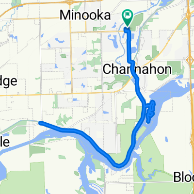
- Herritage Bluff to McKinley Woods and Back
- Distance
- 21.6 km
- Ascent
- 113 m
- Descent
- 120 m
- Location
- Channahon, Illinois, United States of America
Open it in the app