Runde Hainburg an der Donau/Bahnhof über Haslau
A cycling route starting in Hainburg an der Donau, Lower Austria, Austria.
Overview
About this route
Very nice and flat route. From Haslau, the departure from the ferry was a bit confusing as there is no ferry house. However, a phone number is provided - a call clarified things. The ferry is in operation from April to October according to the website - there was an exception on November 1.
- 6 h
- Duration
- 52.6 km
- Distance
- 160 m
- Ascent
- 184 m
- Descent
- 8.8 km/h
- Avg. speed
- 196 m
- Max. altitude
Route photos
Route quality
Waytypes & surfaces along the route
Waytypes
Cycleway
14.2 km
(27 %)
Track
13.7 km
(26 %)
Surfaces
Paved
32.6 km
(62 %)
Unpaved
11.6 km
(22 %)
Asphalt
32.1 km
(61 %)
Gravel
5.8 km
(11 %)
Continue with Bikemap
Use, edit, or download this cycling route
You would like to ride Runde Hainburg an der Donau/Bahnhof über Haslau or customize it for your own trip? Here is what you can do with this Bikemap route:
Free features
- Save this route as favorite or in collections
- Copy & plan your own version of this route
- Sync your route with Garmin or Wahoo
Premium features
Free trial for 3 days, or one-time payment. More about Bikemap Premium.
- Navigate this route on iOS & Android
- Export a GPX / KML file of this route
- Create your custom printout (try it for free)
- Download this route for offline navigation
Discover more Premium features.
Get Bikemap PremiumFrom our community
Other popular routes starting in Hainburg an der Donau
Donau_Etappe_10_Hainburg-Wien- Distance
- 51.3 km
- Ascent
- 129 m
- Descent
- 96 m
- Location
- Hainburg an der Donau, Lower Austria, Austria
Runde Hainburg an der Donau/Bahnhof über Haslau- Distance
- 52.6 km
- Ascent
- 160 m
- Descent
- 184 m
- Location
- Hainburg an der Donau, Lower Austria, Austria
Hainburg - Mannswörth- Distance
- 44.2 km
- Ascent
- 148 m
- Descent
- 138 m
- Location
- Hainburg an der Donau, Lower Austria, Austria
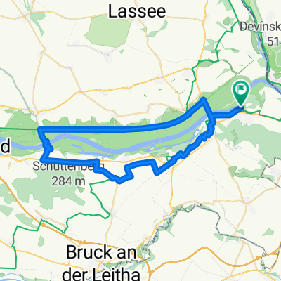
Donau_Etappe_09_Hainburg-Bratislava-Hainburg- Distance
- 34.5 km
- Ascent
- 129 m
- Descent
- 132 m
- Location
- Hainburg an der Donau, Lower Austria, Austria
Deutch-Wagram_máj_ 2018- Distance
- 83.4 km
- Ascent
- 505 m
- Descent
- 507 m
- Location
- Hainburg an der Donau, Lower Austria, Austria
DNV - Lozorno - Biely Kríž - Kačín - DNV- Distance
- 68.8 km
- Ascent
- 624 m
- Descent
- 552 m
- Location
- Hainburg an der Donau, Lower Austria, Austria
Start Donau Cafe Hainburg - Hainburg an der Donau Ungartor nach Stopfenreuther Arm- Distance
- 49.7 km
- Ascent
- 212 m
- Descent
- 209 m
- Location
- Hainburg an der Donau, Lower Austria, Austria
Bratislava do Istrijská- Distance
- 32 km
- Ascent
- 248 m
- Descent
- 237 m
- Location
- Hainburg an der Donau, Lower Austria, Austria
Open it in the app


