

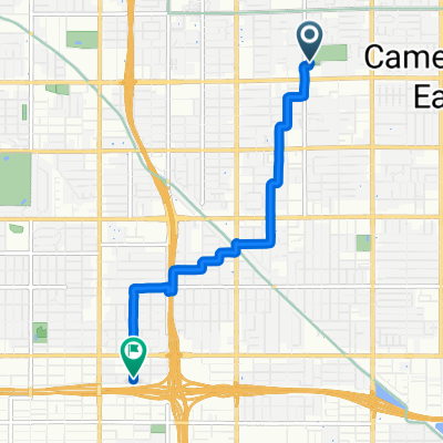
5242 N 20th St, Phoenix to 5242 N 20th St, Phoenix
A cycling route starting in Phoenix, Arizona, United States.
Overview
About this route
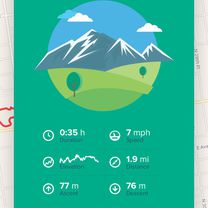
- 3 h 27 min
- Duration
- 21.8 km
- Distance
- 151 m
- Ascent
- 151 m
- Descent
- 6.3 km/h
- Avg. speed
- 430 m
- Max. altitude

Continue with Bikemap
Use, edit, or download this cycling route
You would like to ride 5242 N 20th St, Phoenix to 5242 N 20th St, Phoenix or customize it for your own trip? Here is what you can do with this Bikemap route:
Free features
- Save this route as favorite or in collections
- Copy & plan your own version of this route
- Sync your route with Garmin or Wahoo
Premium features
Free trial for 3 days, or one-time payment. More about Bikemap Premium.
- Navigate this route on iOS & Android
- Export a GPX / KML file of this route
- Create your custom printout (try it for free)
- Download this route for offline navigation
Discover more Premium features.
Get Bikemap PremiumFrom our community
Other popular routes starting in Phoenix
 Home route 1
- Distance
- 40.5 km
- Ascent
- 86 m
- Descent
- 58 m
- Location
- Phoenix, Arizona, United States
 work to Ancala
- Distance
- 38.4 km
- Ascent
- 322 m
- Descent
- 183 m
- Location
- Phoenix, Arizona, United States
 first bike ride around the hood
- Distance
- 3.1 km
- Ascent
- 12 m
- Descent
- 8 m
- Location
- Phoenix, Arizona, United States
 High-speed route in Phoenix
- Distance
- 5.9 km
- Ascent
- 24 m
- Descent
- 61 m
- Location
- Phoenix, Arizona, United States
 Freeport Office
- Distance
- 5.7 km
- Ascent
- 47 m
- Descent
- 55 m
- Location
- Phoenix, Arizona, United States
 58 km J2J
- Distance
- 57.5 km
- Ascent
- 309 m
- Descent
- 307 m
- Location
- Phoenix, Arizona, United States
 Blistering ride in Phoenix
- Distance
- 8.4 km
- Ascent
- 8 m
- Descent
- 0 m
- Location
- Phoenix, Arizona, United States
 Marquee Theater Canal Ride
- Distance
- 31.3 km
- Ascent
- 44 m
- Descent
- 43 m
- Location
- Phoenix, Arizona, United States
Open it in the app