
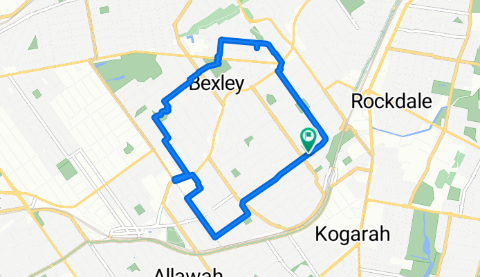
(Map 1) Bexley Bike Bus Route
A cycling route starting in Bexley, New South Wales, Australia.
Overview
About this route
A useful loop around Bexley, Carlton and West Kogarah for students to ride to school, train stations and after-school activities.
-
Marist College Kogarah
-
St Gabriel's Primary School
-
Bethany Catholic College
-
Sydney Technical High School
-
Carlton Public School
-
Kogarah High School (short walk)
-
St George Girls High School (longer walk)
-
Shopfront Arts Co-op
-
Bexley Pool
-
Kogarah Train Station
-
Carlton Train Station
- 29 min
- Duration
- 7.6 km
- Distance
- 72 m
- Ascent
- 72 m
- Descent
- 15.4 km/h
- Avg. speed
- 68 m
- Max. altitude

Continue with Bikemap
Use, edit, or download this cycling route
You would like to ride (Map 1) Bexley Bike Bus Route or customize it for your own trip? Here is what you can do with this Bikemap route:
Free features
- Save this route as favorite or in collections
- Copy & plan your own version of this route
- Sync your route with Garmin or Wahoo
Premium features
Free trial for 3 days, or one-time payment. More about Bikemap Premium.
- Navigate this route on iOS & Android
- Export a GPX / KML file of this route
- Create your custom printout (try it for free)
- Download this route for offline navigation
Discover more Premium features.
Get Bikemap PremiumFrom our community
Other popular routes starting in Bexley
 Kogarah-TownHall
- Distance
- 15.5 km
- Ascent
- 116 m
- Descent
- 94 m
- Location
- Bexley, New South Wales, Australia
 Forest Road 637, Bexley to Forest Road 604, Bexley
- Distance
- 0 km
- Ascent
- 0 m
- Descent
- 0 m
- Location
- Bexley, New South Wales, Australia
 27 Wright Street, Hurstville to 14-16 Hudson Street, Hurstville
- Distance
- 1 km
- Ascent
- 7 m
- Descent
- 6 m
- Location
- Bexley, New South Wales, Australia
 Bexley to Darlinghurst
- Distance
- 14 km
- Ascent
- 101 m
- Descent
- 100 m
- Location
- Bexley, New South Wales, Australia
 71 High Street, Carlton to 76 High Street, Carlton
- Distance
- 40.9 km
- Ascent
- 20 m
- Descent
- 60 m
- Location
- Bexley, New South Wales, Australia
 1–6 Donnan St, Bexley to 1 Donnan St, Bexley
- Distance
- 0.1 km
- Ascent
- 0 m
- Descent
- 0 m
- Location
- Bexley, New South Wales, Australia
 Steady ride in North Sydney
- Distance
- 21.6 km
- Ascent
- 316 m
- Descent
- 304 m
- Location
- Bexley, New South Wales, Australia
 68 Wallace St, Bexley to 66 Wallace St, Bexley
- Distance
- 20.9 km
- Ascent
- 167 m
- Descent
- 169 m
- Location
- Bexley, New South Wales, Australia
Open it in the app