

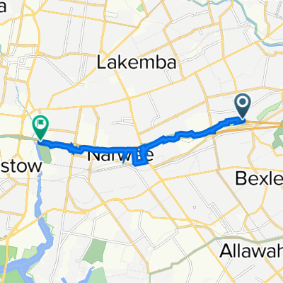
(Map 3D) M5 Linear Park to Bexley Pool
A cycling route starting in Bexley North, New South Wales, Australia.
Overview
About this route
This map is for planning purposes and does not currently exist.
This route relates to suggested upgrades to (Map 3) which it is requested that Bayside Council and the NSW Government deliver.
Features include:
- A new tunnel or bridge to link the M5 Linear Park with Kookaburra Lane.
- An ATL along Bardwell Creek through vacant land.
- Utilisation of Preddys Lane and Council land to connect with Highgate St.
- 11 min
- Duration
- 2.7 km
- Distance
- 32 m
- Ascent
- 16 m
- Descent
- 15 km/h
- Avg. speed
- 44 m
- Max. altitude

Continue with Bikemap
Use, edit, or download this cycling route
You would like to ride (Map 3D) M5 Linear Park to Bexley Pool or customize it for your own trip? Here is what you can do with this Bikemap route:
Free features
- Save this route as favorite or in collections
- Copy & plan your own version of this route
- Sync your route with Garmin or Wahoo
Premium features
Free trial for 3 days, or one-time payment. More about Bikemap Premium.
- Navigate this route on iOS & Android
- Export a GPX / KML file of this route
- Create your custom printout (try it for free)
- Download this route for offline navigation
Discover more Premium features.
Get Bikemap PremiumFrom our community
Other popular routes starting in Bexley North
 Bexley North to Salt Pan Creek Reserve (M5 East Tunnel Cycleway)
- Distance
- 8.4 km
- Ascent
- 54 m
- Descent
- 67 m
- Location
- Bexley North, New South Wales, Australia
 Bexley Rd, Kingsgrove to 3 The Crescent, Kingsgrove
- Distance
- 4.7 km
- Ascent
- 30 m
- Descent
- 18 m
- Location
- Bexley North, New South Wales, Australia
 Westconnex, Bexley North to 3 Irwin Cr, Bexley North
- Distance
- 8 km
- Ascent
- 61 m
- Descent
- 61 m
- Location
- Bexley North, New South Wales, Australia
 Kingsland road to Struthers st
- Distance
- 19 km
- Ascent
- 98 m
- Descent
- 129 m
- Location
- Bexley North, New South Wales, Australia
 9 Calbina Road, Earlwood to 13 Calbina Road, Earlwood
- Distance
- 22.6 km
- Ascent
- 34 m
- Descent
- 57 m
- Location
- Bexley North, New South Wales, Australia
 Clemton Park to Lakemba
- Distance
- 3.4 km
- Ascent
- 44 m
- Descent
- 29 m
- Location
- Bexley North, New South Wales, Australia
 Bexley North to Cooks River
- Distance
- 3.7 km
- Ascent
- 32 m
- Descent
- 45 m
- Location
- Bexley North, New South Wales, Australia
 63 Shaw Street, Bexley North to 29 Fletcher Street, Campsie
- Distance
- 3.7 km
- Ascent
- 42 m
- Descent
- 22 m
- Location
- Bexley North, New South Wales, Australia
Open it in the app