

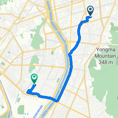
공릉동 704-5, 서울특별시 to 번동 418-17, 서울특별시
A cycling route starting in Guri-si, Gyeonggi-do, South Korea.
Overview
About this route
- 39 min
- Duration
- 6.2 km
- Distance
- 35 m
- Ascent
- 19 m
- Descent
- 9.6 km/h
- Avg. speed
- 39 m
- Max. altitude
Continue with Bikemap
Use, edit, or download this cycling route
You would like to ride 공릉동 704-5, 서울특별시 to 번동 418-17, 서울특별시 or customize it for your own trip? Here is what you can do with this Bikemap route:
Free features
- Save this route as favorite or in collections
- Copy & plan your own version of this route
- Sync your route with Garmin or Wahoo
Premium features
Free trial for 3 days, or one-time payment. More about Bikemap Premium.
- Navigate this route on iOS & Android
- Export a GPX / KML file of this route
- Create your custom printout (try it for free)
- Download this route for offline navigation
Discover more Premium features.
Get Bikemap PremiumFrom our community
Other popular routes starting in Guri-si
 느린 주행
느린 주행- Distance
- 16.7 km
- Ascent
- 34 m
- Descent
- 59 m
- Location
- Guri-si, Gyeonggi-do, South Korea
 20251002서울야간라이딩
- Distance
- 26 km
- Ascent
- 138 m
- Descent
- 162 m
- Location
- Guri-si, Gyeonggi-do, South Korea
![휘경동 294-278Ph0]으로 라우팅](https://media.bikemap.net/routes/17638243/gallery/thumbs/30e89364-3889-4176-b9bf-9c61176e261a.jpg.208x208_q80_crop.jpg) 휘경동 294-278Ph0]으로 라우팅
휘경동 294-278Ph0]으로 라우팅- Distance
- 26.2 km
- Ascent
- 153 m
- Descent
- 162 m
- Location
- Guri-si, Gyeonggi-do, South Korea
 Guri-Seoul
- Distance
- 31 km
- Ascent
- 150 m
- Descent
- 173 m
- Location
- Guri-si, Gyeonggi-do, South Korea
![묵동 238-91Ph0]으로 라우팅](https://media.bikemap.net/routes/17574202/gallery/thumbs/04f9673e-93ee-4069-80d4-4b0b2ca1fd58.jpg.208x208_q80_crop.jpg) 묵동 238-91Ph0]으로 라우팅
묵동 238-91Ph0]으로 라우팅- Distance
- 6.5 km
- Ascent
- 44 m
- Descent
- 78 m
- Location
- Guri-si, Gyeonggi-do, South Korea
 53-3 53-3 ~ 장안동 192-75
- Distance
- 6.4 km
- Ascent
- 59 m
- Descent
- 87 m
- Location
- Guri-si, Gyeonggi-do, South Korea
 구의동 546-1 ~ 물금읍 898-2, 양산시
- Distance
- 478.9 km
- Ascent
- 5,702 m
- Descent
- 5,724 m
- Location
- Guri-si, Gyeonggi-do, South Korea
 Seoul Hangang
- Distance
- 31.2 km
- Ascent
- 91 m
- Descent
- 95 m
- Location
- Guri-si, Gyeonggi-do, South Korea
Open it in the app