

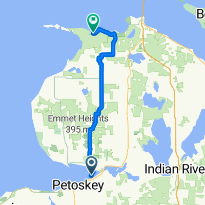
Huron- Day 2- Petoskey to Mackinac Bridge
A cycling route starting in Petoskey, Michigan, United States.
Overview
About this route
- -:--
- Duration
- 86.9 km
- Distance
- 229 m
- Ascent
- 230 m
- Descent
- ---
- Avg. speed
- ---
- Max. altitude

Route quality
Waytypes & surfaces along the route
Waytypes
Quiet road
18.3 km
(21 %)
Road
17.4 km
(20 %)
Surfaces
Paved
80.8 km
(93 %)
Unpaved
2.6 km
(3 %)
Asphalt
55.6 km
(64 %)
Paved (undefined)
25.2 km
(29 %)
Continue with Bikemap
Use, edit, or download this cycling route
You would like to ride Huron- Day 2- Petoskey to Mackinac Bridge or customize it for your own trip? Here is what you can do with this Bikemap route:
Free features
- Save this route as favorite or in collections
- Copy & plan your own version of this route
- Split it into stages to create a multi-day tour
- Sync your route with Garmin or Wahoo
Premium features
Free trial for 3 days, or one-time payment. More about Bikemap Premium.
- Navigate this route on iOS & Android
- Export a GPX / KML file of this route
- Create your custom printout (try it for free)
- Download this route for offline navigation
Discover more Premium features.
Get Bikemap PremiumFrom our community
Other popular routes starting in Petoskey
 N Western Michigan Trail, Petoskey to 7525 US-31, Alanson
- Distance
- 18.9 km
- Ascent
- 28 m
- Descent
- 28 m
- Location
- Petoskey, Michigan, United States
 Woodland Avenue 2011, Petoskey to Bayside Avenue 1250, Petoskey
- Distance
- 81.1 km
- Ascent
- 706 m
- Descent
- 708 m
- Location
- Petoskey, Michigan, United States
 1890 US-131, Petoskey to Lake Shore Dr, Charlevoix
- Distance
- 67.2 km
- Ascent
- 504 m
- Descent
- 603 m
- Location
- Petoskey, Michigan, United States
 Petosky state park to Leggs Inn
- Distance
- 42.3 km
- Ascent
- 307 m
- Descent
- 295 m
- Location
- Petoskey, Michigan, United States
 Petoskey to Harbor Springs
- Distance
- 15.8 km
- Ascent
- 79 m
- Descent
- 93 m
- Location
- Petoskey, Michigan, United States
 Crooked LK/Mackinaw
- Distance
- 124.8 km
- Ascent
- 553 m
- Descent
- 553 m
- Location
- Petoskey, Michigan, United States
 Petoskey SP to Wilderness SP
- Distance
- 53 km
- Ascent
- 225 m
- Descent
- 236 m
- Location
- Petoskey, Michigan, United States
 Petoskey to 284 Harbor Dr E, Harbor Springs
- Distance
- 9.2 km
- Ascent
- 46 m
- Descent
- 61 m
- Location
- Petoskey, Michigan, United States
Open it in the app