th么nes et alpages des Confins
A cycling route starting in Th么nes, Auvergne-Rh么ne-Alpes, France.
Overview
About this route
We offer you a panoramic view of the Aravis mountain range throughout the route, with the lake and alpine pastures of Les Confins as a reward. Take advantage of the climb to pause in La Clusaz. At Les Confins, head on foot towards the Pointe du Danay. From up there, you'll see all the most beautiful valleys of the Aravis.
- -:--
- Duration
- 17.4 km
- Distance
- 836 m
- Ascent
- 82 m
- Descent
- ---
- Avg. speed
- ---
- Max. altitude
Route quality
Waytypes & surfaces along the route
Waytypes
Quiet road
12.1 km
(70 %)
Road
0.7 km
(4 %)
Undefined
4.5 km
(26 %)
Surfaces
Paved
7.8 km
(45 %)
Asphalt
7.8 km
(45 %)
Undefined
9.5 km
(55 %)
Route highlights
Points of interest along the route
Point of interest after 0 km
izialpes.com. Location de v茅lo 茅lectrique de randonn茅e
Point of interest after 0 km
h么tel de l'Hermitage. Bike hotel. Super accueil, chambre confortable. Un 2* qui vaut largement 3*. Manque la piscine, mais celle du village est 脿 100m.
Continue with Bikemap
Use, edit, or download this cycling route
You would like to ride th么nes et alpages des Confins or customize it for your own trip? Here is what you can do with this Bikemap route:
Free features
- Save this route as favorite or in collections
- Copy & plan your own version of this route
- Sync your route with Garmin or Wahoo
Premium features
Free trial for 3 days, or one-time payment. More about Bikemap Premium.
- Navigate this route on iOS & Android
- Export a GPX / KML file of this route
- Create your custom printout (try it for free)
- Download this route for offline navigation
Discover more Premium features.
Get Bikemap PremiumFrom our community
Other popular routes starting in Th么nes
- Day 4 Leg 4 col de la fry to annecy finish!
- Distance
- 32.4 km
- Ascent
- 158 m
- Descent
- 1,020 m
- Location
- Th么nes, Auvergne-Rh么ne-Alpes, France
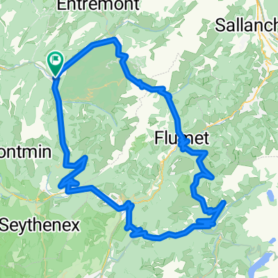
- JH Manigod -> Thones -> La Clusaz -> Manigod
- Distance
- 31.4 km
- Ascent
- 881 m
- Descent
- 881 m
- Location
- Th么nes, Auvergne-Rh么ne-Alpes, France
- fier naves
- Distance
- 48.1 km
- Ascent
- 629 m
- Descent
- 629 m
- Location
- Th么nes, Auvergne-Rh么ne-Alpes, France
- Col de la Croix Fry via Col de Plan Bois
- Distance
- 41.2 km
- Ascent
- 1,476 m
- Descent
- 1,384 m
- Location
- Th么nes, Auvergne-Rh么ne-Alpes, France
- 9 agosto 2023
- Distance
- 54.1 km
- Ascent
- 771 m
- Descent
- 954 m
- Location
- Th么nes, Auvergne-Rh么ne-Alpes, France
- 3 Cols: Croix Fry, Aravis, Merdassier
- Distance
- 49.3 km
- Ascent
- 1,384 m
- Descent
- 1,384 m
- Location
- Th么nes, Auvergne-Rh么ne-Alpes, France
- Col de la Croix Fry and Aravis
- Distance
- 52.1 km
- Ascent
- 1,564 m
- Descent
- 1,551 m
- Location
- Th么nes, Auvergne-Rh么ne-Alpes, France
- thones annecy en electric bike
- Distance
- 48.2 km
- Ascent
- 506 m
- Descent
- 507 m
- Location
- Th么nes, Auvergne-Rh么ne-Alpes, France
Open it in the app