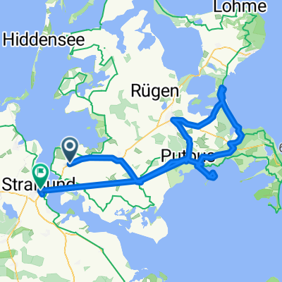
5. NWR am 17.06.2012
A cycling route starting in Rambin, Mecklenburg-Vorpommern, Germany.
Overview
About this route
- -:--
- Duration
- 50.1 km
- Distance
- 44 m
- Ascent
- 47 m
- Descent
- ---
- Avg. speed
- ---
- Max. altitude
Route quality
Waytypes & surfaces along the route
Waytypes
Quiet road
20.3 km
(40 %)
Track
10 km
(20 %)
Surfaces
Paved
41.7 km
(83 %)
Unpaved
4.6 km
(9 %)
Asphalt
17.7 km
(35 %)
Paved (undefined)
12.1 km
(24 %)
Route highlights
Points of interest along the route
Point of interest after 25.8 km
Halbzeit nach ca. 25 km
Continue with Bikemap
Use, edit, or download this cycling route
You would like to ride 5. NWR am 17.06.2012 or customize it for your own trip? Here is what you can do with this Bikemap route:
Free features
- Save this route as favorite or in collections
- Copy & plan your own version of this route
- Sync your route with Garmin or Wahoo
Premium features
Free trial for 3 days, or one-time payment. More about Bikemap Premium.
- Navigate this route on iOS & Android
- Export a GPX / KML file of this route
- Create your custom printout (try it for free)
- Download this route for offline navigation
Discover more Premium features.
Get Bikemap PremiumFrom our community
Other popular routes starting in Rambin
- Weekend trip MNN
- Distance
- 85.4 km
- Ascent
- 181 m
- Descent
- 189 m
- Location
- Rambin, Mecklenburg-Vorpommern, Germany
- 5. NWR am 17.06.2012
- Distance
- 50.1 km
- Ascent
- 44 m
- Descent
- 47 m
- Location
- Rambin, Mecklenburg-Vorpommern, Germany
- Götemitz 16, Rambin nach Götemitz 13–16, Rambin
- Distance
- 25.2 km
- Ascent
- 69 m
- Descent
- 70 m
- Location
- Rambin, Mecklenburg-Vorpommern, Germany
- Gemütliche Route in Altefähr
- Distance
- 13.5 km
- Ascent
- 3 m
- Descent
- 3 m
- Location
- Rambin, Mecklenburg-Vorpommern, Germany
- Saalkow, Gustow nach Saalkow, Gustow
- Distance
- 26.9 km
- Ascent
- 51 m
- Descent
- 50 m
- Location
- Rambin, Mecklenburg-Vorpommern, Germany
- Stubbenkammertour
- Distance
- 65.4 km
- Ascent
- 482 m
- Descent
- 454 m
- Location
- Rambin, Mecklenburg-Vorpommern, Germany
- Rnde von Rampin nach Altefär
- Distance
- 21.3 km
- Ascent
- 53 m
- Descent
- 50 m
- Location
- Rambin, Mecklenburg-Vorpommern, Germany
- Dorfstraße 9, Rambin nach Hauptstraße 2, Rambin
- Distance
- 45.1 km
- Ascent
- 66 m
- Descent
- 69 m
- Location
- Rambin, Mecklenburg-Vorpommern, Germany
Open it in the app