
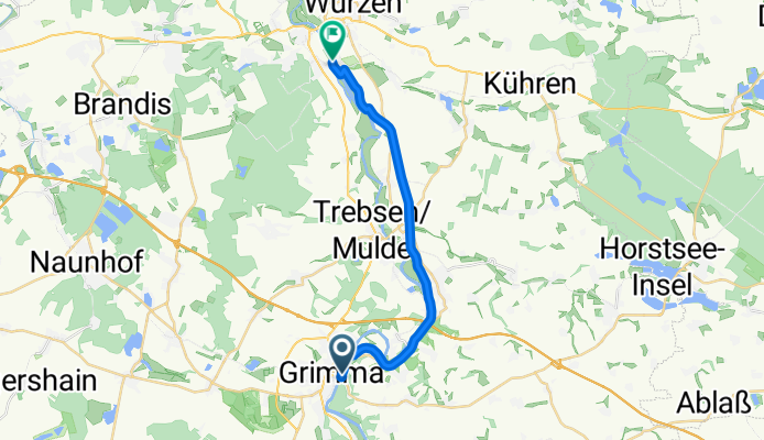
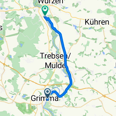
Grimma-Dehnitz.Grimma
A cycling route starting in Grimma, Saxony, Germany.
Overview
About this route
Beautiful cycling route for MTB AND ROAD BIKE. Directly at the Mulde. For MTB, small diversions on gravel are possible. 17.5 km out.....enjoy good food and 17.5 km back to the parking lot.
From there, more routes are possible.
- -:--
- Duration
- 17.4 km
- Distance
- 23 m
- Ascent
- 37 m
- Descent
- ---
- Avg. speed
- 140 m
- Max. altitude
Route quality
Waytypes & surfaces along the route
Waytypes
Path
7.7 km
(44 %)
Cycleway
5.8 km
(33 %)
Surfaces
Paved
15.4 km
(88 %)
Unpaved
0.3 km
(2 %)
Asphalt
15.4 km
(88 %)
Unpaved (undefined)
0.3 km
(2 %)
Undefined
1.7 km
(10 %)
Route highlights
Points of interest along the route
Point of interest after 0 km
Start Parkplatz
Continue with Bikemap
Use, edit, or download this cycling route
You would like to ride Grimma-Dehnitz.Grimma or customize it for your own trip? Here is what you can do with this Bikemap route:
Free features
- Save this route as favorite or in collections
- Copy & plan your own version of this route
- Sync your route with Garmin or Wahoo
Premium features
Free trial for 3 days, or one-time payment. More about Bikemap Premium.
- Navigate this route on iOS & Android
- Export a GPX / KML file of this route
- Create your custom printout (try it for free)
- Download this route for offline navigation
Discover more Premium features.
Get Bikemap PremiumFrom our community
Other popular routes starting in Grimma
 20250530_Zwickauer_Mulde_Etappe5
- Distance
- 28.5 km
- Ascent
- 110 m
- Descent
- 115 m
- Location
- Grimma, Saxony, Germany
 Grimma nach Freiberg
- Distance
- 81.2 km
- Ascent
- 866 m
- Descent
- 611 m
- Location
- Grimma, Saxony, Germany
 Recovered Route
- Distance
- 21.5 km
- Ascent
- 202 m
- Descent
- 202 m
- Location
- Grimma, Saxony, Germany
 Mit dem E Scooter von Grimma nach Prag (inkl. Ladestops minimum 30km Reichweite pro Station)
- Distance
- 353.8 km
- Ascent
- 2,568 m
- Descent
- 2,555 m
- Location
- Grimma, Saxony, Germany
 Waldweg 19, Grimma nach Waldweg 32, Grimma
- Distance
- 21.1 km
- Ascent
- 122 m
- Descent
- 123 m
- Location
- Grimma, Saxony, Germany
 Grimma-Markranstädt Tour 2011
- Distance
- 60.5 km
- Ascent
- 107 m
- Descent
- 159 m
- Location
- Grimma, Saxony, Germany
 Grimma-Dehnitz.Grimma
- Distance
- 17.4 km
- Ascent
- 23 m
- Descent
- 37 m
- Location
- Grimma, Saxony, Germany
 Störmthal-Grimma-Kössern
- Distance
- 46.2 km
- Ascent
- 171 m
- Descent
- 165 m
- Location
- Grimma, Saxony, Germany
Open it in the app