

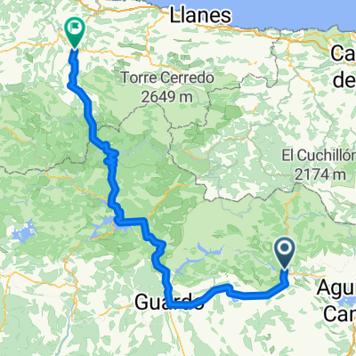
Praderas y Vistas de Altura . Cervera de Pisuerga
A cycling route starting in Cervera de Pisuerga, Castille and León, Spain.
Overview
About this route
Salida de Cervera por psitas todo, atravesando por Praderas de Val Sadornill. En Liguerzana se cruza el rio Pisuerga por su puente, para retroceder hasta el pueblo de Vado a la orilla del rio. Por pistas agrícolas se llega hasta el pueblo de Barrio Santa Maria. Donde comienza la ascensión mas dura hasta el alto de la Ruya, donde hay un molino eólico. Por pistas se accede hasta Dehesa de Montejo, y tras cruzar la carretera general nos adentramos por caminos entre robles hasta Cervera.
- -:--
- Duration
- 48.5 km
- Distance
- 884 m
- Ascent
- 887 m
- Descent
- ---
- Avg. speed
- 1,223 m
- Max. altitude
Route quality
Waytypes & surfaces along the route
Waytypes
Track
40.8 km
(84 %)
Quiet road
4.9 km
(10 %)
Surfaces
Paved
0.5 km
(1 %)
Unpaved
27.2 km
(56 %)
Gravel
8.7 km
(18 %)
Sand
7.8 km
(16 %)
Continue with Bikemap
Use, edit, or download this cycling route
You would like to ride Praderas y Vistas de Altura . Cervera de Pisuerga or customize it for your own trip? Here is what you can do with this Bikemap route:
Free features
- Save this route as favorite or in collections
- Copy & plan your own version of this route
- Sync your route with Garmin or Wahoo
Premium features
Free trial for 3 days, or one-time payment. More about Bikemap Premium.
- Navigate this route on iOS & Android
- Export a GPX / KML file of this route
- Create your custom printout (try it for free)
- Download this route for offline navigation
Discover more Premium features.
Get Bikemap PremiumFrom our community
Other popular routes starting in Cervera de Pisuerga
 Lechetronica 2013
- Distance
- 163.7 km
- Ascent
- 0 m
- Descent
- 0 m
- Location
- Cervera de Pisuerga, Castille and León, Spain
 cervera 1
- Distance
- 23.5 km
- Ascent
- 666 m
- Descent
- 371 m
- Location
- Cervera de Pisuerga, Castille and León, Spain
 Cervera de Pisugera - Boca de Huérgano
- Distance
- 62 km
- Ascent
- 813 m
- Descent
- 712 m
- Location
- Cervera de Pisuerga, Castille and León, Spain
 Imported route
- Distance
- 135.2 km
- Ascent
- 944 m
- Descent
- 1,877 m
- Location
- Cervera de Pisuerga, Castille and León, Spain
 Ruta de los Pantanos
- Distance
- 97.2 km
- Ascent
- 729 m
- Descent
- 729 m
- Location
- Cervera de Pisuerga, Castille and León, Spain
 Cervera de Pisuerga - Tresviso
- Distance
- 83.1 km
- Ascent
- 500 m
- Descent
- 1,463 m
- Location
- Cervera de Pisuerga, Castille and León, Spain
 Cervera de Pisuerga - Boca de Huérgano
- Distance
- 64.2 km
- Ascent
- 610 m
- Descent
- 500 m
- Location
- Cervera de Pisuerga, Castille and León, Spain
 Tag 4 von Cervera de Pisuera nach Mediana de Pomar
- Distance
- 112.7 km
- Ascent
- 634 m
- Descent
- 1,055 m
- Location
- Cervera de Pisuerga, Castille and León, Spain
Open it in the app