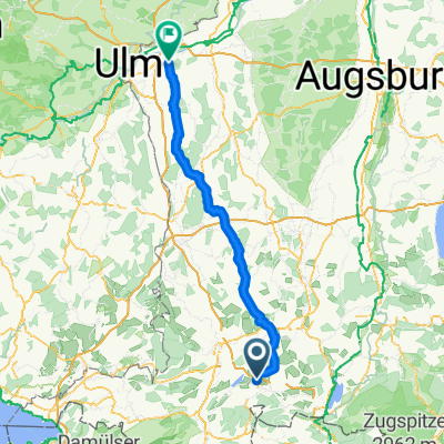
Grüntensee - Haldensee
A cycling route starting in Oy-Mittelberg, Bavaria, Germany.
Overview
About this route
- -:--
- Duration
- 55.2 km
- Distance
- 509 m
- Ascent
- 509 m
- Descent
- ---
- Avg. speed
- ---
- Max. altitude
Route quality
Waytypes & surfaces along the route
Waytypes
Busy road
30 km
(54 %)
Road
15.2 km
(27 %)
Surfaces
Paved
43.6 km
(79 %)
Unpaved
0 km
(<1 %)
Asphalt
43.4 km
(79 %)
Paved (undefined)
0.2 km
(<1 %)
Continue with Bikemap
Use, edit, or download this cycling route
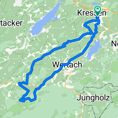
You would like to ride Grüntensee - Haldensee or customize it for your own trip? Here is what you can do with this Bikemap route:
Free features
- Save this route as favorite or in collections
- Copy & plan your own version of this route
- Sync your route with Garmin or Wahoo
Premium features
Free trial for 3 days, or one-time payment. More about Bikemap Premium.
- Navigate this route on iOS & Android
- Export a GPX / KML file of this route
- Create your custom printout (try it for free)
- Download this route for offline navigation
Discover more Premium features.
Get Bikemap PremiumFrom our community
Other popular routes starting in Oy-Mittelberg
- 9. Wertach-Oberstaufen-64km-670Hm
- Distance
- 65.6 km
- Ascent
- 597 m
- Descent
- 697 m
- Location
- Oy-Mittelberg, Bavaria, Germany
- Grüntensee-Pfronten
- Distance
- 17 km
- Ascent
- 198 m
- Descent
- 222 m
- Location
- Oy-Mittelberg, Bavaria, Germany
- Radtour durch Deutschland 3392 km Teil 26
- Distance
- 78 km
- Ascent
- 450 m
- Descent
- 776 m
- Location
- Oy-Mittelberg, Bavaria, Germany
- Rottachsee Allgäu Rottachsee
- Distance
- 87.6 km
- Ascent
- 1,172 m
- Descent
- 1,172 m
- Location
- Oy-Mittelberg, Bavaria, Germany
- Tour der Lukas
- Distance
- 81.6 km
- Ascent
- 1,651 m
- Descent
- 2,005 m
- Location
- Oy-Mittelberg, Bavaria, Germany
- Oy Mittelberg - Rottachseetour, Allgäu (Deutschland)
- Distance
- 27.3 km
- Ascent
- 388 m
- Descent
- 390 m
- Location
- Oy-Mittelberg, Bavaria, Germany
- Grüntensee
- Distance
- 35.5 km
- Ascent
- 787 m
- Descent
- 774 m
- Location
- Oy-Mittelberg, Bavaria, Germany
- Mountenbikerunde Wertach-Tannheimer Tal - Achtal - Wertach
- Distance
- 58.3 km
- Ascent
- 596 m
- Descent
- 596 m
- Location
- Oy-Mittelberg, Bavaria, Germany
Open it in the app