

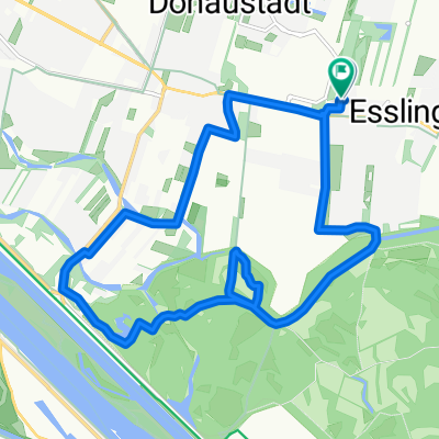
Von Wien nach Schloss Eckartsau und zurück
A cycling route starting in Groß-Enzersdorf, Lower Austria, Austria.
Overview
About this route
The cycling tour starts in Vienna along the Danube riverbank up to the OMV, where it crosses the site. The path then follows the Hubertus embankment through the floodplain area of the Donau-Auen National Park. In spring, numerous plant species bloom on the embankment. Near Schönau, the bike path makes a curve over the Schönauer Traverse. The narrow Schönau floodplain forest strip is one of the most dynamic areas of the national park. From the outer Schönauer Traverse, there are impressive views of the Kühwörther Wasser with its large reed beds. The route continues on the Danube Cycle Path over the Hubertus embankment. A long straight stretch lined by large meadows and floodplain forest. At Eckartsau, the path then leads left uphill to the castle. There is a bicycle service station in the castle park, and the castle café with a shop invites visitors to linger. The extensive meadows around Eckartsau Castle are accessible to guests. You will also find a national park information point and an exhibition there. The return journey takes the same route.
- -:--
- Duration
- 57.4 km
- Distance
- 230 m
- Ascent
- 230 m
- Descent
- ---
- Avg. speed
- 166 m
- Max. altitude

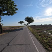
Route photos

Route quality
Waytypes & surfaces along the route
Waytypes
Cycleway
24.1 km
(42 %)
Access road
16.6 km
(29 %)
Surfaces
Paved
51.7 km
(90 %)
Unpaved
5.2 km
(9 %)
Asphalt
51.7 km
(90 %)
Gravel
5.2 km
(9 %)
Undefined
0.6 km
(1 %)
Continue with Bikemap
Use, edit, or download this cycling route
You would like to ride Von Wien nach Schloss Eckartsau und zurück or customize it for your own trip? Here is what you can do with this Bikemap route:
Free features
- Save this route as favorite or in collections
- Copy & plan your own version of this route
- Sync your route with Garmin or Wahoo
Premium features
Free trial for 3 days, or one-time payment. More about Bikemap Premium.
- Navigate this route on iOS & Android
- Export a GPX / KML file of this route
- Create your custom printout (try it for free)
- Download this route for offline navigation
Discover more Premium features.
Get Bikemap PremiumFrom our community
Other popular routes starting in Groß-Enzersdorf
 Groß-Enzersdorf-Deutsch Wagram-Straßhof- Leopoldsdorf im Marchfeld Runde. 🚴♂️🚴
- Distance
- 63.3 km
- Ascent
- 37 m
- Descent
- 38 m
- Location
- Groß-Enzersdorf, Lower Austria, Austria
 Alte Donau - Donaukanal Runde. 🚴♂️🚴
- Distance
- 47.4 km
- Ascent
- 111 m
- Descent
- 113 m
- Location
- Groß-Enzersdorf, Lower Austria, Austria
 Essling-Mühlwasser-Dechantlacke-Lobau-Essling
- Distance
- 15.6 km
- Ascent
- 44 m
- Descent
- 46 m
- Location
- Groß-Enzersdorf, Lower Austria, Austria
 Lobau Runde 1
- Distance
- 21.7 km
- Ascent
- 67 m
- Descent
- 66 m
- Location
- Groß-Enzersdorf, Lower Austria, Austria
 Obere Lobau Runde
- Distance
- 18 km
- Ascent
- 107 m
- Descent
- 107 m
- Location
- Groß-Enzersdorf, Lower Austria, Austria
 Biberhaufenweg 173, Wien nach Biberhaufenweg 228, Wien
- Distance
- 21.3 km
- Ascent
- 29 m
- Descent
- 72 m
- Location
- Groß-Enzersdorf, Lower Austria, Austria
 Aspern - Innermanzing/Eck lang
- Distance
- 79.8 km
- Ascent
- 703 m
- Descent
- 393 m
- Location
- Groß-Enzersdorf, Lower Austria, Austria
 lobau-runde 2
- Distance
- 39.4 km
- Ascent
- 122 m
- Descent
- 122 m
- Location
- Groß-Enzersdorf, Lower Austria, Austria
Open it in the app