

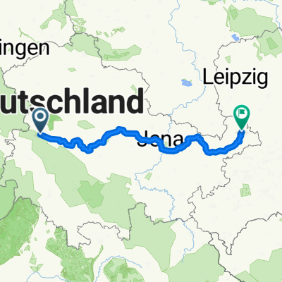
Erster Tag auf dem Rennsteig
A cycling route starting in Eisenach, Thuringia, Germany.
Overview
About this route
nun ging es los der erste Tag war ganz schön hart und auch vom technichen Anspruch doch schn schwieriger.das wetter war super .Teilweise sehr Verwurzelt steil und verblockt so das man auch mal schieben mus .Nur selten sind wir auf dem Rennsteigradweg gefahren,neistens ging es immer auf dem Wanderweg endlang.
- -:--
- Duration
- 93.7 km
- Distance
- 1,362 m
- Ascent
- 866 m
- Descent
- ---
- Avg. speed
- ---
- Max. altitude

Continue with Bikemap
Use, edit, or download this cycling route
You would like to ride Erster Tag auf dem Rennsteig or customize it for your own trip? Here is what you can do with this Bikemap route:
Free features
- Save this route as favorite or in collections
- Copy & plan your own version of this route
- Split it into stages to create a multi-day tour
- Sync your route with Garmin or Wahoo
Premium features
Free trial for 3 days, or one-time payment. More about Bikemap Premium.
- Navigate this route on iOS & Android
- Export a GPX / KML file of this route
- Create your custom printout (try it for free)
- Download this route for offline navigation
Discover more Premium features.
Get Bikemap PremiumFrom our community
Other popular routes starting in Eisenach
 Eisenach -Kerspenhausen
- Distance
- 79.7 km
- Ascent
- 537 m
- Descent
- 549 m
- Location
- Eisenach, Thuringia, Germany
 Trailschaukel Eisenach
- Distance
- 35.8 km
- Ascent
- 923 m
- Descent
- 923 m
- Location
- Eisenach, Thuringia, Germany
 12.07.24 Eisenach-Wilhelmglücksbrunn
- Distance
- 34.3 km
- Ascent
- 245 m
- Descent
- 245 m
- Location
- Eisenach, Thuringia, Germany
 Rund um den Hainich_t
- Distance
- 116.4 km
- Ascent
- 1,237 m
- Descent
- 1,239 m
- Location
- Eisenach, Thuringia, Germany
 07.Wer.Eisen.-Philipst.
- Distance
- 195.8 km
- Ascent
- 2,079 m
- Descent
- 1,479 m
- Location
- Eisenach, Thuringia, Germany
 Zentraler Thüringer Wald
- Distance
- 99.9 km
- Ascent
- 1,260 m
- Descent
- 1,260 m
- Location
- Eisenach, Thuringia, Germany
 kurze Tour
- Distance
- 17.3 km
- Ascent
- 213 m
- Descent
- 205 m
- Location
- Eisenach, Thuringia, Germany
 Thüringer Radfernwege - 11 - Thüringer Städtekette - D-Route 4
- Distance
- 233.6 km
- Ascent
- 1,500 m
- Descent
- 1,543 m
- Location
- Eisenach, Thuringia, Germany
Open it in the app