
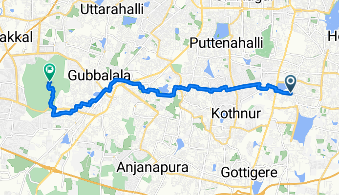
thurahalli forest
A cycling route starting in Bengaluru, Karnataka, India.
Overview
About this route
- 42 min
- Duration
- 11.7 km
- Distance
- 122 m
- Ascent
- 142 m
- Descent
- 16.8 km/h
- Avg. speed
- 930 m
- Avg. speed
Route quality
Waytypes & surfaces along the route
Waytypes
Quiet road
7.4 km
(63 %)
Road
2.7 km
(23 %)
Surfaces
Paved
0.8 km
(7 %)
Unpaved
1.4 km
(12 %)
Ground
1.1 km
(10 %)
Asphalt
0.8 km
(7 %)
Continue with Bikemap
Use, edit, or download this cycling route
You would like to ride thurahalli forest or customize it for your own trip? Here is what you can do with this Bikemap route:
Free features
- Save this route as favorite or in collections
- Copy & plan your own version of this route
- Sync your route with Garmin or Wahoo
Premium features
Free trial for 3 days, or one-time payment. More about Bikemap Premium.
- Navigate this route on iOS & Android
- Export a GPX / KML file of this route
- Create your custom printout (try it for free)
- Download this route for offline navigation
Discover more Premium features.
Get Bikemap PremiumFrom our community
Other popular routes starting in Bengaluru
 Benniganahalli Lake ❤️
- Distance
- 11 km
- Ascent
- 312 m
- Descent
- 262 m
- Location
- Bengaluru, Karnataka, India
 Outer Ring Road 16, Bengaluru to Kuvempu Road 205, Bengaluru
- Distance
- 39.9 km
- Ascent
- 571 m
- Descent
- 585 m
- Location
- Bengaluru, Karnataka, India
 5th Main Road, Bengaluru to Bellandur Lake Road, Bengaluru
- Distance
- 10.7 km
- Ascent
- 186 m
- Descent
- 186 m
- Location
- Bengaluru, Karnataka, India
 Route to Bengaluru
- Distance
- 6 km
- Ascent
- 23 m
- Descent
- 27 m
- Location
- Bengaluru, Karnataka, India
 Route to Swamy Vivekananda Road, Bengaluru
- Distance
- 2.6 km
- Ascent
- 28 m
- Descent
- 28 m
- Location
- Bengaluru, Karnataka, India
 Yemalur Road, Bengaluru to Yemalur Road, Bengaluru
- Distance
- 23.5 km
- Ascent
- 127 m
- Descent
- 126 m
- Location
- Bengaluru, Karnataka, India
 Moderate route in
- Distance
- 13.4 km
- Ascent
- 300 m
- Descent
- 308 m
- Location
- Bengaluru, Karnataka, India
 India Map car
- Distance
- 49.6 km
- Ascent
- 461 m
- Descent
- 461 m
- Location
- Bengaluru, Karnataka, India
Open it in the app