
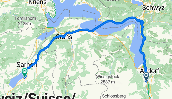
Overview
About this route
- 4 h 35 min
- Duration
- 60.3 km
- Distance
- 1,597 m
- Ascent
- 1,602 m
- Descent
- 13.2 km/h
- Avg. speed
- 800 m
- Max. altitude
Part of
2025_ALPX
8 stages
Route quality
Waytypes & surfaces along the route
Waytypes
Quiet road
12.7 km
(21 %)
Track
10.2 km
(17 %)
Surfaces
Paved
35 km
(58 %)
Unpaved
8.4 km
(14 %)
Asphalt
33.8 km
(56 %)
Gravel
8.4 km
(14 %)
Route highlights
Points of interest along the route
Drinking water after 10.2 km
Drinking water after 13.5 km
Bike service after 15.2 km
Ladestation
Drinking water after 15.2 km
Drinking water after 19.2 km
Drinking water after 28.2 km
Drinking water after 35.3 km
Drinking water after 54 km
Continue with Bikemap
Use, edit, or download this cycling route
You would like to ride V2_E03_ALPX_Schweiz or customize it for your own trip? Here is what you can do with this Bikemap route:
Free features
- Save this route as favorite or in collections
- Copy & plan your own version of this route
- Sync your route with Garmin or Wahoo
Premium features
Free trial for 3 days, or one-time payment. More about Bikemap Premium.
- Navigate this route on iOS & Android
- Export a GPX / KML file of this route
- Create your custom printout (try it for free)
- Download this route for offline navigation
Discover more Premium features.
Get Bikemap PremiumFrom our community
Other popular routes starting in Attinghausen
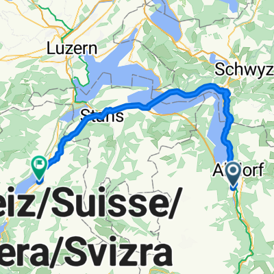
 Schattdorf-Andermatt
- Distance
- 35.5 km
- Ascent
- 1,043 m
- Descent
- 84 m
- Location
- Attinghausen, Canton of Uri, Switzerland
 Attinghausen-Klauenpass-Eggberge-Attinghausen
- Distance
- 58.9 km
- Ascent
- 2,242 m
- Descent
- 2,240 m
- Location
- Attinghausen, Canton of Uri, Switzerland
 Attinghausen - Erstfeld- Attingh.
- Distance
- 10.8 km
- Ascent
- 284 m
- Descent
- 279 m
- Location
- Attinghausen, Canton of Uri, Switzerland
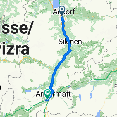 Attinghausen - Andermatt
- Distance
- 36.9 km
- Ascent
- 1,813 m
- Descent
- 745 m
- Location
- Attinghausen, Canton of Uri, Switzerland
 Attinghausen-Brüsti-Attinghausen
- Distance
- 18.2 km
- Ascent
- 1,319 m
- Descent
- 1,320 m
- Location
- Attinghausen, Canton of Uri, Switzerland
 V2_E03_ALPX_Schweiz
- Distance
- 60.3 km
- Ascent
- 1,597 m
- Descent
- 1,602 m
- Location
- Attinghausen, Canton of Uri, Switzerland
 Surenenpass-Erstfeld
- Distance
- 11.6 km
- Ascent
- 77 m
- Descent
- 1,881 m
- Location
- Attinghausen, Canton of Uri, Switzerland
 Attinghausen-Ribi-Urigen-Alp_Selez-Eggberge-Attinghausen
- Distance
- 43.6 km
- Ascent
- 1,638 m
- Descent
- 1,636 m
- Location
- Attinghausen, Canton of Uri, Switzerland
Open it in the app