

Day 608
A cycling route starting in Ōme, Tokyo, Japan.
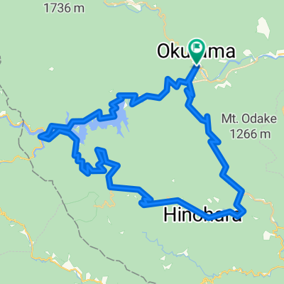
Overview
About this route
- -:--
- Duration
- 50.7 km
- Distance
- 60 m
- Ascent
- 225 m
- Descent
- ---
- Avg. speed
- 183 m
- Max. altitude

Continue with Bikemap
Use, edit, or download this cycling route
You would like to ride Day 608 or customize it for your own trip? Here is what you can do with this Bikemap route:
Free features
- Save this route as favorite or in collections
- Copy & plan your own version of this route
- Sync your route with Garmin or Wahoo
Premium features
Free trial for 3 days, or one-time payment. More about Bikemap Premium.
- Navigate this route on iOS & Android
- Export a GPX / KML file of this route
- Create your custom printout (try it for free)
- Download this route for offline navigation
Discover more Premium features.
Get Bikemap PremiumFrom our community
Other popular routes starting in Ōme
 リハビリライド
- Distance
- 111.8 km
- Ascent
- 4,925 m
- Descent
- 4,760 m
- Location
- Ōme, Tokyo, Japan
 2013 wiggle 東京グランフォンド
- Distance
- 89.7 km
- Ascent
- 4,753 m
- Descent
- 4,758 m
- Location
- Ōme, Tokyo, Japan
 奥多摩サイクリング_柳沢峠
- Distance
- 57.1 km
- Ascent
- 1,286 m
- Descent
- 1,209 m
- Location
- Ōme, Tokyo, Japan
 奥多摩ー柳沢ー笹子ー大月
- Distance
- 93.8 km
- Ascent
- 1,918 m
- Descent
- 1,895 m
- Location
- Ōme, Tokyo, Japan
 日原鍾乳洞
日原鍾乳洞- Distance
- 66.1 km
- Ascent
- 697 m
- Descent
- 702 m
- Location
- Ōme, Tokyo, Japan
 naguriko dirt
- Distance
- 39.8 km
- Ascent
- 908 m
- Descent
- 905 m
- Location
- Ōme, Tokyo, Japan
 鋸山林道&風張林道
- Distance
- 56.1 km
- Ascent
- 1,487 m
- Descent
- 1,488 m
- Location
- Ōme, Tokyo, Japan
 鋸山林道(奥多摩〜武蔵五日市)
- Distance
- 27.7 km
- Ascent
- 807 m
- Descent
- 964 m
- Location
- Ōme, Tokyo, Japan
Open it in the app