

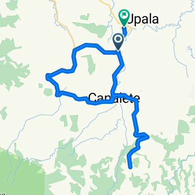
vuelta a cuatro cruces
A cycling route starting in Upala, Alajuela Province, Costa Rica.
Overview
About this route
- 1 h 30 min
- Duration
- 21.8 km
- Distance
- 131 m
- Ascent
- 128 m
- Descent
- 14.6 km/h
- Avg. speed
- 124 m
- Max. altitude

Route quality
Waytypes & surfaces along the route
Waytypes
Quiet road
17.9 km
(82 %)
Road
3.9 km
(18 %)
Surfaces
Unpaved
7 km
(32 %)
Unpaved (undefined)
7 km
(32 %)
Undefined
14.8 km
(68 %)
Continue with Bikemap
Use, edit, or download this cycling route
You would like to ride vuelta a cuatro cruces or customize it for your own trip? Here is what you can do with this Bikemap route:
Free features
- Save this route as favorite or in collections
- Copy & plan your own version of this route
- Sync your route with Garmin or Wahoo
Premium features
Free trial for 3 days, or one-time payment. More about Bikemap Premium.
- Navigate this route on iOS & Android
- Export a GPX / KML file of this route
- Create your custom printout (try it for free)
- Download this route for offline navigation
Discover more Premium features.
Get Bikemap PremiumFrom our community
Other popular routes starting in Upala
 Paseo lento en Upala
- Distance
- 44.9 km
- Ascent
- 33 m
- Descent
- 65 m
- Location
- Upala, Alajuela Province, Costa Rica
 De 729 a Costa Rica, Upala
- Distance
- 6.3 km
- Ascent
- 15 m
- Descent
- 33 m
- Location
- Upala, Alajuela Province, Costa Rica
 De Upala a VXXP+M38, Upala
- Distance
- 43.5 km
- Ascent
- 122 m
- Descent
- 291 m
- Location
- Upala, Alajuela Province, Costa Rica
 Ruta canalete
- Distance
- 12.7 km
- Ascent
- 26 m
- Descent
- 58 m
- Location
- Upala, Alajuela Province, Costa Rica
 De Avenida 3, Upala a VXXP+M38, Upala
- Distance
- 29.6 km
- Ascent
- 36 m
- Descent
- 56 m
- Location
- Upala, Alajuela Province, Costa Rica
 Costa Rica Rundtour 2010 - 13
- Distance
- 83.8 km
- Ascent
- 536 m
- Descent
- 333 m
- Location
- Upala, Alajuela Province, Costa Rica
 De Corredor Noratlántico a Corredor Noratlántico
- Distance
- 38.6 km
- Ascent
- 274 m
- Descent
- 280 m
- Location
- Upala, Alajuela Province, Costa Rica
 De Provincia de Alajuela a Provincia de Alajuela
- Distance
- 31.6 km
- Ascent
- 117 m
- Descent
- 118 m
- Location
- Upala, Alajuela Province, Costa Rica
Open it in the app