Ricken - Hemberg - Schwägalp - Hulftegg
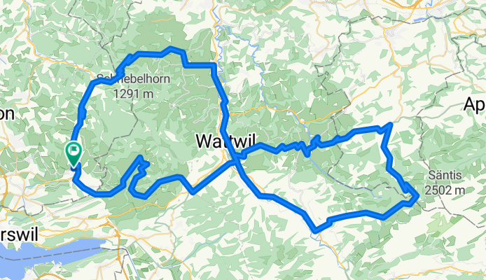
A cycling route starting in Wald, Canton of Zurich, Switzerland.
Overview
About this route
- -:--
- Duration
- 115.8 km
- Distance
- 1,705 m
- Ascent
- 1,705 m
- Descent
- ---
- Avg. speed
- ---
- Max. altitude
Route quality
Waytypes & surfaces along the route
Waytypes
Road
48.8 km
(42 %)
Busy road
43 km
(37 %)
Surfaces
Paved
108.7 km
(94 %)
Unpaved
1.1 km
(<1 %)
Asphalt
108.4 km
(94 %)
Gravel
0.7 km
(<1 %)
Continue with Bikemap
Use, edit, or download this cycling route
You would like to ride Ricken - Hemberg - Schwägalp - Hulftegg or customize it for your own trip? Here is what you can do with this Bikemap route:
Free features
- Save this route as favorite or in collections
- Copy & plan your own version of this route
- Split it into stages to create a multi-day tour
- Sync your route with Garmin or Wahoo
Premium features
Free trial for 3 days, or one-time payment. More about Bikemap Premium.
- Navigate this route on iOS & Android
- Export a GPX / KML file of this route
- Create your custom printout (try it for free)
- Download this route for offline navigation
Discover more Premium features.
Get Bikemap PremiumFrom our community
Other popular routes starting in Wald
- wald circuit
- Distance
- 108.6 km
- Ascent
- 1,018 m
- Descent
- 1,017 m
- Location
- Wald, Canton of Zurich, Switzerland
- Ricken - Hemberg - Schwägalp - Hulftegg
- Distance
- 115.8 km
- Ascent
- 1,705 m
- Descent
- 1,705 m
- Location
- Wald, Canton of Zurich, Switzerland
- Jonastrasse 17B, Wald nach Bahnhofstrasse 36, Wald
- Distance
- 33.3 km
- Ascent
- 1,570 m
- Descent
- 1,557 m
- Location
- Wald, Canton of Zurich, Switzerland
- ZH Wald- Kollbrunn Appenzellerland
- Distance
- 72.5 km
- Ascent
- 953 m
- Descent
- 1,067 m
- Location
- Wald, Canton of Zurich, Switzerland
- Wald-Schnebelehorn-Hörnli-..
- Distance
- 39.4 km
- Ascent
- 976 m
- Descent
- 976 m
- Location
- Wald, Canton of Zurich, Switzerland
- Bachtel Allmen
- Distance
- 35.5 km
- Ascent
- 1,568 m
- Descent
- 1,560 m
- Location
- Wald, Canton of Zurich, Switzerland
- B/Gibswil-Bachtel
- Distance
- 38.7 km
- Ascent
- 733 m
- Descent
- 733 m
- Location
- Wald, Canton of Zurich, Switzerland
- Oberland Zürich
- Distance
- 37.5 km
- Ascent
- 1,649 m
- Descent
- 1,640 m
- Location
- Wald, Canton of Zurich, Switzerland
Open it in the app