

Alpenrunde Teil 7
A cycling route starting in Reutte, Tyrol, Austria.
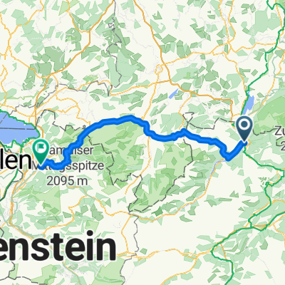
Overview
About this route
From Reutte to Oetz via the Fernpass and through Imst in the Inn valley. Scratched the 2000m barrier for the first time. Many accommodation options in Oetz.
- -:--
- Duration
- 72.8 km
- Distance
- 1,839 m
- Ascent
- 1,906 m
- Descent
- ---
- Avg. speed
- 1,909 m
- Max. altitude

Route quality
Waytypes & surfaces along the route
Waytypes
Track
18.9 km
(26 %)
Road
12.4 km
(17 %)
Surfaces
Paved
55.3 km
(76 %)
Unpaved
4.4 km
(6 %)
Asphalt
53.1 km
(73 %)
Unpaved (undefined)
3.6 km
(5 %)
Route highlights
Points of interest along the route

Point of interest after 36.8 km
Auf dem Weg zum Hahntennjoch
Continue with Bikemap
Use, edit, or download this cycling route
You would like to ride Alpenrunde Teil 7 or customize it for your own trip? Here is what you can do with this Bikemap route:
Free features
- Save this route as favorite or in collections
- Copy & plan your own version of this route
- Sync your route with Garmin or Wahoo
Premium features
Free trial for 3 days, or one-time payment. More about Bikemap Premium.
- Navigate this route on iOS & Android
- Export a GPX / KML file of this route
- Create your custom printout (try it for free)
- Download this route for offline navigation
Discover more Premium features.
Get Bikemap PremiumFrom our community
Other popular routes starting in Reutte
 Via Claudia Augusta 4
- Distance
- 63.3 km
- Ascent
- 640 m
- Descent
- 789 m
- Location
- Reutte, Tyrol, Austria
 fern
fern- Distance
- 32 km
- Ascent
- 503 m
- Descent
- 262 m
- Location
- Reutte, Tyrol, Austria
 Reutte-Tannheimertal-Engetal-Pfronten 53m
- Distance
- 52.2 km
- Ascent
- 832 m
- Descent
- 833 m
- Location
- Reutte, Tyrol, Austria
 Reutte-Runde
- Distance
- 136.6 km
- Ascent
- 2,213 m
- Descent
- 2,212 m
- Location
- Reutte, Tyrol, Austria
 Reutte - Dornbirn (Romberg) über Deutschland
- Distance
- 115.4 km
- Ascent
- 1,196 m
- Descent
- 1,504 m
- Location
- Reutte, Tyrol, Austria
 Alpencross Mai 2010 Reutte/Tirol - Biberwier
- Distance
- 25.7 km
- Ascent
- 420 m
- Descent
- 286 m
- Location
- Reutte, Tyrol, Austria
 lechtal Tour
- Distance
- 116.6 km
- Ascent
- 983 m
- Descent
- 725 m
- Location
- Reutte, Tyrol, Austria
 Reute - Navene
- Distance
- 342.4 km
- Ascent
- 1,449 m
- Descent
- 2,180 m
- Location
- Reutte, Tyrol, Austria
Open it in the app