

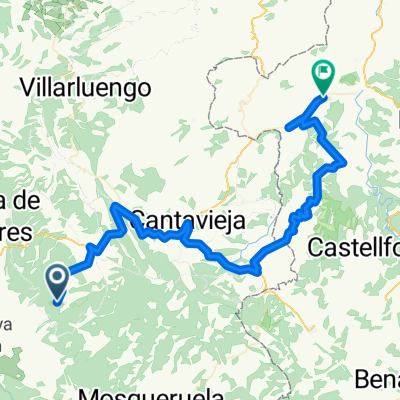
Puerto de Villarroya (por Fortanete)
A cycling route starting in Fortanete, Aragon, Spain.
Overview
About this route
The Puerto de Villarroya, located in the province of Teruel, Spain, is a mountain pass that stands out for its natural beauty and its relevance in the sporting arena, especially in cycling. This pass is situated in the Cuencas Mineras region, near the town of Villarroya de los Pinares, in the heart of the Sierra de Gúdar. Its privileged position makes it an interesting point for nature lovers and outdoor sports enthusiasts.
- 36 min
- Duration
- 9.9 km
- Distance
- 395 m
- Ascent
- 40 m
- Descent
- 16.6 km/h
- Avg. speed
- 1,703 m
- Max. altitude

Route photos
\"")
Route quality
Waytypes & surfaces along the route
Waytypes
Quiet road
0.1 km
(1 %)
Track
0.1 km
(1 %)
Undefined
9.7 km
(98 %)
Continue with Bikemap
Use, edit, or download this cycling route
You would like to ride Puerto de Villarroya (por Fortanete) or customize it for your own trip? Here is what you can do with this Bikemap route:
Free features
- Save this route as favorite or in collections
- Copy & plan your own version of this route
- Sync your route with Garmin or Wahoo
Premium features
Free trial for 3 days, or one-time payment. More about Bikemap Premium.
- Navigate this route on iOS & Android
- Export a GPX / KML file of this route
- Create your custom printout (try it for free)
- Download this route for offline navigation
Discover more Premium features.
Get Bikemap PremiumFrom our community
Other popular routes starting in Fortanete
 silent route
- Distance
- 55.5 km
- Ascent
- 964 m
- Descent
- 1,599 m
- Location
- Fortanete, Aragon, Spain
 Fortanete - Todolella
- Distance
- 75.2 km
- Ascent
- 0 m
- Descent
- 1,040 m
- Location
- Fortanete, Aragon, Spain
 Spanje dag 4
- Distance
- 88.8 km
- Ascent
- 1,042 m
- Descent
- 1,659 m
- Location
- Fortanete, Aragon, Spain
 Fortanete - Teruel
- Distance
- 72.8 km
- Ascent
- 1,020 m
- Descent
- 1,462 m
- Location
- Fortanete, Aragon, Spain
 Teruel Extrem 2009
- Distance
- 200.6 km
- Ascent
- 5,344 m
- Descent
- 5,261 m
- Location
- Fortanete, Aragon, Spain
 cabaña-puerto valdelinares
- Distance
- 96.7 km
- Ascent
- 1,732 m
- Descent
- 1,728 m
- Location
- Fortanete, Aragon, Spain
 Puerto de Villarroya (por Fortanete)
- Distance
- 9.9 km
- Ascent
- 395 m
- Descent
- 40 m
- Location
- Fortanete, Aragon, Spain
 silent route
- Distance
- 56.2 km
- Ascent
- 977 m
- Descent
- 1,615 m
- Location
- Fortanete, Aragon, Spain
Open it in the app