Mandach - Ampferenhöhe - Bözen
A cycling route starting in Ormalingen, Basel-Landschaft, Switzerland.
Overview
About this route
From Rothenfluh via Asp- Eiken - Laufenbfurg- Leibstadt - Mandacherhöhe - Bözen - Frick - Wittnauerhöhe back to Rothenfluh. at about 24°. Time 3 hours on the road.
- -:--
- Duration
- 75 km
- Distance
- 1,006 m
- Ascent
- 999 m
- Descent
- ---
- Avg. speed
- ---
- Max. altitude
Route quality
Waytypes & surfaces along the route
Waytypes
Road
28.5 km
(38 %)
Quiet road
5.3 km
(7 %)
Surfaces
Paved
69 km
(92 %)
Unpaved
0.8 km
(1 %)
Asphalt
56.3 km
(75 %)
Paved (undefined)
12.8 km
(17 %)
Continue with Bikemap
Use, edit, or download this cycling route
You would like to ride Mandach - Ampferenhöhe - Bözen or customize it for your own trip? Here is what you can do with this Bikemap route:
Free features
- Save this route as favorite or in collections
- Copy & plan your own version of this route
- Sync your route with Garmin or Wahoo
Premium features
Free trial for 3 days, or one-time payment. More about Bikemap Premium.
- Navigate this route on iOS & Android
- Export a GPX / KML file of this route
- Create your custom printout (try it for free)
- Download this route for offline navigation
Discover more Premium features.
Get Bikemap PremiumFrom our community
Other popular routes starting in Ormalingen
- Albtal - St. Blasien - Wehratal
- Distance
- 121.2 km
- Ascent
- 1,196 m
- Descent
- 1,190 m
- Location
- Ormalingen, Basel-Landschaft, Switzerland
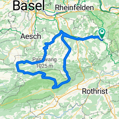
- Passwang - Unt. Hauenstein
- Distance
- 113.1 km
- Ascent
- 1,210 m
- Descent
- 1,204 m
- Location
- Ormalingen, Basel-Landschaft, Switzerland
- training13
- Distance
- 35.9 km
- Ascent
- 863 m
- Descent
- 863 m
- Location
- Ormalingen, Basel-Landschaft, Switzerland
- Tecknau Luzern Waldvariante
- Distance
- 87.7 km
- Ascent
- 1,451 m
- Descent
- 1,459 m
- Location
- Ormalingen, Basel-Landschaft, Switzerland
- Oberer und Unterer Hauenstein mit Rothrist und Kölliken
- Distance
- 114.3 km
- Ascent
- 966 m
- Descent
- 955 m
- Location
- Ormalingen, Basel-Landschaft, Switzerland
- Hauenstein - Teufelsschlucht - Longbridge
- Distance
- 72.3 km
- Ascent
- 776 m
- Descent
- 783 m
- Location
- Ormalingen, Basel-Landschaft, Switzerland
- Rothenfluh - Diegten - Langenbruck - Mümliswil - Passwang - Büsserach - Fehren - Nunningen - Reigoldswil - Oberdorf - Hölstein - Diegten - Sissach - Rothenfluh
- Distance
- 102 km
- Ascent
- 1,490 m
- Descent
- 1,490 m
- Location
- Ormalingen, Basel-Landschaft, Switzerland
- Mandach - Ampferenhöhe - Bözen
- Distance
- 75 km
- Ascent
- 1,006 m
- Descent
- 999 m
- Location
- Ormalingen, Basel-Landschaft, Switzerland
Open it in the app