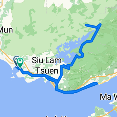
藍地交匯處, 屯門藍地 to 正大街, 流浮山
A cycling route starting in Tuenmen, Tuen Mun, Hong Kong.
Overview
About this route
- 1 h 23 min
- Duration
- 12.2 km
- Distance
- 184 m
- Ascent
- 189 m
- Descent
- 8.9 km/h
- Avg. speed
- 56 m
- Max. altitude
Continue with Bikemap
Use, edit, or download this cycling route
You would like to ride 藍地交匯處, 屯門藍地 to 正大街, 流浮山 or customize it for your own trip? Here is what you can do with this Bikemap route:
Free features
- Save this route as favorite or in collections
- Copy & plan your own version of this route
- Sync your route with Garmin or Wahoo
Premium features
Free trial for 3 days, or one-time payment. More about Bikemap Premium.
- Navigate this route on iOS & Android
- Export a GPX / KML file of this route
- Create your custom printout (try it for free)
- Download this route for offline navigation
Discover more Premium features.
Get Bikemap PremiumFrom our community
Other popular routes starting in Tuenmen
Sunny Bay Loops- Distance
- 9.9 km
- Ascent
- 80 m
- Descent
- 80 m
- Location
- Tuenmen, Tuen Mun, Hong Kong
屯門 - 下白泥- Distance
- 21.2 km
- Ascent
- 99 m
- Descent
- 125 m
- Location
- Tuenmen, Tuen Mun, Hong Kong
屯赤隧道、尖鼻咀、天水圍、Accro Coffee、上水- Distance
- 55.7 km
- Ascent
- 973 m
- Descent
- 961 m
- Location
- Tuenmen, Tuen Mun, Hong Kong
輕鬆的路線 元朗- Distance
- 13.8 km
- Ascent
- 68 m
- Descent
- 66 m
- Location
- Tuenmen, Tuen Mun, Hong Kong
one way trip 2- Distance
- 16.2 km
- Ascent
- 569 m
- Descent
- 573 m
- Location
- Tuenmen, Tuen Mun, Hong Kong
欣澳至梅窩登山包括乘車時間- Distance
- 28.6 km
- Ascent
- 949 m
- Descent
- 951 m
- Location
- Tuenmen, Tuen Mun, Hong Kong
碼頭>青龍頭- Distance
- 20.7 km
- Ascent
- 970 m
- Descent
- 970 m
- Location
- Tuenmen, Tuen Mun, Hong Kong
wetland park- Distance
- 13.6 km
- Ascent
- 194 m
- Descent
- 245 m
- Location
- Tuenmen, Tuen Mun, Hong Kong
Open it in the app

