
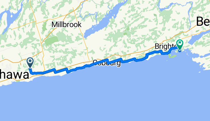
Overview
About this route
- 5 h 47 min
- Duration
- 101.8 km
- Distance
- 486 m
- Ascent
- 547 m
- Descent
- 17.6 km/h
- Avg. speed
- 157 m
- Max. altitude

Part of

Canada
17 stages
Route quality
Waytypes & surfaces along the route
Waytypes
Road
31.4 km
(31 %)
Quiet road
20.7 km
(20 %)
Surfaces
Paved
38.5 km
(38 %)
Unpaved
0.2 km
(<1 %)
Asphalt
32.1 km
(31 %)
Paved (undefined)
6.3 km
(6 %)
Continue with Bikemap
Use, edit, or download this cycling route
You would like to ride Day_6_Bowmanville to Brighton or customize it for your own trip? Here is what you can do with this Bikemap route:
Free features
- Save this route as favorite or in collections
- Copy & plan your own version of this route
- Split it into stages to create a multi-day tour
- Sync your route with Garmin or Wahoo
Premium features
Free trial for 3 days, or one-time payment. More about Bikemap Premium.
- Navigate this route on iOS & Android
- Export a GPX / KML file of this route
- Create your custom printout (try it for free)
- Download this route for offline navigation
Discover more Premium features.
Get Bikemap PremiumFrom our community
Other popular routes starting in Oshawa
 Oshawa to Guildwood Via Oshawa Creek, Waterfront Trail, Duffin's and Highland Creeks
- Distance
- 58.8 km
- Ascent
- 382 m
- Descent
- 348 m
- Location
- Oshawa, Ontario, Canada
 Taunton Road to Frederick St. “Power Line Trail”! Whitby Ontario
- Distance
- 7.1 km
- Ascent
- 34 m
- Descent
- 27 m
- Location
- Oshawa, Ontario, Canada
 McLaughlin Bay through Darlington Prov Park.
- Distance
- 3.9 km
- Ascent
- 40 m
- Descent
- 32 m
- Location
- Oshawa, Ontario, Canada
 Michael Star path and Harmony Creek path loop through Oshawa
- Distance
- 30.3 km
- Ascent
- 156 m
- Descent
- 154 m
- Location
- Oshawa, Ontario, Canada
 Cedar Valley Trail
- Distance
- 2.8 km
- Ascent
- 10 m
- Descent
- 9 m
- Location
- Oshawa, Ontario, Canada
 Double path oshawa
- Distance
- 29.5 km
- Ascent
- 124 m
- Descent
- 127 m
- Location
- Oshawa, Ontario, Canada
 Waterfront Trail - Bowmanville to Port Hope and back
- Distance
- 79.4 km
- Ascent
- 486 m
- Descent
- 482 m
- Location
- Oshawa, Ontario, Canada
 643 Lakeview Ave, Oshawa to 647 Lakeview Ave, Oshawa
- Distance
- 17.6 km
- Ascent
- 62 m
- Descent
- 61 m
- Location
- Oshawa, Ontario, Canada
Open it in the app