

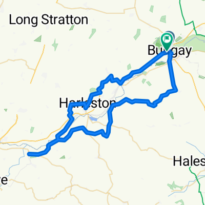
2 Meadow View, Bungay to 9 Nethergate Street, Bungay
A cycling route starting in Bungay, England, United Kingdom.
Overview
About this route
- 59 min
- Duration
- 17.4 km
- Distance
- 29 m
- Ascent
- 29 m
- Descent
- 17.9 km/h
- Avg. speed
- 14 m
- Max. altitude
Route quality
Waytypes & surfaces along the route
Waytypes
Road
10.3 km
(59 %)
Quiet road
6.6 km
(38 %)
Cycleway
0.5 km
(3 %)
Surfaces
Paved
3.5 km
(20 %)
Asphalt
3.5 km
(20 %)
Undefined
14 km
(80 %)
Continue with Bikemap
Use, edit, or download this cycling route
You would like to ride 2 Meadow View, Bungay to 9 Nethergate Street, Bungay or customize it for your own trip? Here is what you can do with this Bikemap route:
Free features
- Save this route as favorite or in collections
- Copy & plan your own version of this route
- Sync your route with Garmin or Wahoo
Premium features
Free trial for 3 days, or one-time payment. More about Bikemap Premium.
- Navigate this route on iOS & Android
- Export a GPX / KML file of this route
- Create your custom printout (try it for free)
- Download this route for offline navigation
Discover more Premium features.
Get Bikemap PremiumFrom our community
Other popular routes starting in Bungay
 100 mile Parkinsons Ride
- Distance
- 165.2 km
- Ascent
- 306 m
- Descent
- 305 m
- Location
- Bungay, England, United Kingdom
 Middle Road to Middle Road
- Distance
- 22.7 km
- Ascent
- 132 m
- Descent
- 136 m
- Location
- Bungay, England, United Kingdom
 Fire Station, Hillside Road W, Bungay to 55 Flixton Road, Bungay
- Distance
- 5 km
- Ascent
- 36 m
- Descent
- 40 m
- Location
- Bungay, England, United Kingdom
 Out to Eye and back
- Distance
- 69.8 km
- Ascent
- 129 m
- Descent
- 129 m
- Location
- Bungay, England, United Kingdom
 bungay loop1
- Distance
- 82.6 km
- Ascent
- 315 m
- Descent
- 320 m
- Location
- Bungay, England, United Kingdom
 Bungay - Ellingham - Ditchingham Sprint
- Distance
- 10.2 km
- Ascent
- 14 m
- Descent
- 14 m
- Location
- Bungay, England, United Kingdom
 2 Meadow View, Bungay to 9 Nethergate Street, Bungay
- Distance
- 17.4 km
- Ascent
- 29 m
- Descent
- 29 m
- Location
- Bungay, England, United Kingdom
 bungay hoxne
- Distance
- 54.9 km
- Ascent
- 186 m
- Descent
- 187 m
- Location
- Bungay, England, United Kingdom
Open it in the app