

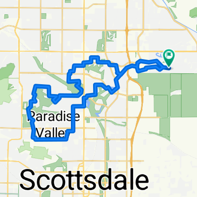
Scottsdale Loop
A cycling route starting in Scottsdale, Arizona, United States.
Overview
About this route
Nice urban ride with a lot of bike lane and some bicycle path.
- 2 h 20 min
- Duration
- 29.7 km
- Distance
- 98 m
- Ascent
- 98 m
- Descent
- 12.8 km/h
- Avg. speed
- 422 m
- Max. altitude

Route photos

Continue with Bikemap
Use, edit, or download this cycling route
You would like to ride Scottsdale Loop or customize it for your own trip? Here is what you can do with this Bikemap route:
Free features
- Save this route as favorite or in collections
- Copy & plan your own version of this route
- Sync your route with Garmin or Wahoo
Premium features
Free trial for 3 days, or one-time payment. More about Bikemap Premium.
- Navigate this route on iOS & Android
- Export a GPX / KML file of this route
- Create your custom printout (try it for free)
- Download this route for offline navigation
Discover more Premium features.
Get Bikemap PremiumFrom our community
Other popular routes starting in Scottsdale
 11796–11798 E Stonegate Cir, Scottsdale to 16300 McDowell Mountain Park Dr, Scottsdale
- Distance
- 28.2 km
- Ascent
- 340 m
- Descent
- 180 m
- Location
- Scottsdale, Arizona, United States
 backroads pizza run
- Distance
- 21 km
- Ascent
- 114 m
- Descent
- 112 m
- Location
- Scottsdale, Arizona, United States
 4419 N Scottsdale Rd, Scottsdale to 7769 E Joshua Tree Ln, Scottsdale
- Distance
- 7.9 km
- Ascent
- 26 m
- Descent
- 22 m
- Location
- Scottsdale, Arizona, United States
 Tempe Lake-Scottsdale loop
- Distance
- 31.1 km
- Ascent
- 86 m
- Descent
- 88 m
- Location
- Scottsdale, Arizona, United States
 3200 N Hayden Rd, Scottsdale to 2915 N 84th Pl, Scottsdale
- Distance
- 1.4 km
- Ascent
- 3 m
- Descent
- 3 m
- Location
- Scottsdale, Arizona, United States
 LaMarche Work
- Distance
- 22.7 km
- Ascent
- 200 m
- Descent
- 65 m
- Location
- Scottsdale, Arizona, United States
 Scottsdale Ranch to Mummy Mountain Loop
- Distance
- 41.9 km
- Ascent
- 197 m
- Descent
- 197 m
- Location
- Scottsdale, Arizona, United States
 Scottsdale Grayhawk Road Ride
- Distance
- 67.9 km
- Ascent
- 562 m
- Descent
- 561 m
- Location
- Scottsdale, Arizona, United States
Open it in the app