

danabari edition
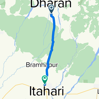
A cycling route starting in Dharān, Eastern Region, Nepal.
Overview
About this route
25jan2025 me with sulak and rajeshdai
- 3 h 21 min
- Duration
- 34.1 km
- Distance
- 2,383 m
- Ascent
- 2,447 m
- Descent
- 10.2 km/h
- Avg. speed
- 1,711 m
- Max. altitude

Route quality
Waytypes & surfaces along the route
Waytypes
Road
13.3 km
(39 %)
Quiet road
7.8 km
(23 %)
Surfaces
Paved
1.7 km
(5 %)
Asphalt
1.7 km
(5 %)
Undefined
32.4 km
(95 %)
Continue with Bikemap
Use, edit, or download this cycling route
You would like to ride danabari edition or customize it for your own trip? Here is what you can do with this Bikemap route:
Free features
- Save this route as favorite or in collections
- Copy & plan your own version of this route
- Sync your route with Garmin or Wahoo
Premium features
Free trial for 3 days, or one-time payment. More about Bikemap Premium.
- Navigate this route on iOS & Android
- Export a GPX / KML file of this route
- Create your custom printout (try it for free)
- Download this route for offline navigation
Discover more Premium features.
Get Bikemap PremiumFrom our community
Other popular routes starting in Dharān
 Jana Path, Dharan to Mahendra Path, Dharan
- Distance
- 9.3 km
- Ascent
- 168 m
- Descent
- 119 m
- Location
- Dharān, Eastern Region, Nepal
 Cracking ride in char koshi gadi
- Distance
- 15.5 km
- Ascent
- 3 m
- Descent
- 244 m
- Location
- Dharān, Eastern Region, Nepal
 letang to biratnagar
- Distance
- 37.8 km
- Ascent
- 27 m
- Descent
- 192 m
- Location
- Dharān, Eastern Region, Nepal
 Easy ride in
- Distance
- 99.6 km
- Ascent
- 1,255 m
- Descent
- 1,429 m
- Location
- Dharān, Eastern Region, Nepal
 family tour
- Distance
- 15.9 km
- Ascent
- 342 m
- Descent
- 4 m
- Location
- Dharān, Eastern Region, Nepal
 danabari edition
- Distance
- 34.1 km
- Ascent
- 2,383 m
- Descent
- 2,447 m
- Location
- Dharān, Eastern Region, Nepal
Open it in the app