

-19.906, -40.604 a -19.936, -40.599
A cycling route starting in Santa Teresa, Espírito Santo, Brazil.
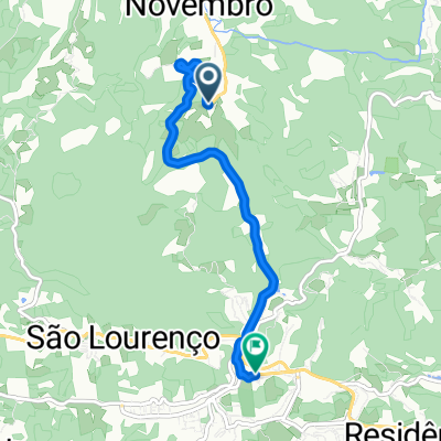
Overview
About this route
- 10 min
- Duration
- 6.4 km
- Distance
- 284 m
- Ascent
- 39 m
- Descent
- 39.3 km/h
- Avg. speed
- 689 m
- Max. altitude

Route quality
Waytypes & surfaces along the route
Waytypes
Busy road
5.6 km
(88 %)
Quiet road
0.5 km
(9 %)
Surfaces
Paved
6.2 km
(96 %)
Paved (undefined)
4.9 km
(77 %)
Asphalt
1.2 km
(19 %)
Undefined
0.2 km
(4 %)
Continue with Bikemap
Use, edit, or download this cycling route
You would like to ride -19.906, -40.604 a -19.936, -40.599 or customize it for your own trip? Here is what you can do with this Bikemap route:
Free features
- Save this route as favorite or in collections
- Copy & plan your own version of this route
- Sync your route with Garmin or Wahoo
Premium features
Free trial for 3 days, or one-time payment. More about Bikemap Premium.
- Navigate this route on iOS & Android
- Export a GPX / KML file of this route
- Create your custom printout (try it for free)
- Download this route for offline navigation
Discover more Premium features.
Get Bikemap PremiumFrom our community
Other popular routes starting in Santa Teresa
 aquecimento
- Distance
- 5.3 km
- Ascent
- 160 m
- Descent
- 158 m
- Location
- Santa Teresa, Espírito Santo, Brazil
 -19.906, -40.604 a -19.936, -40.599
- Distance
- 6.4 km
- Ascent
- 284 m
- Descent
- 39 m
- Location
- Santa Teresa, Espírito Santo, Brazil
 III Desafio das Montanhas
- Distance
- 42.1 km
- Ascent
- 784 m
- Descent
- 784 m
- Location
- Santa Teresa, Espírito Santo, Brazil
 caminho do Imigrante 1º parte
- Distance
- 30.7 km
- Ascent
- 310 m
- Descent
- 1,082 m
- Location
- Santa Teresa, Espírito Santo, Brazil
 SEGUNDO DESAFIO DAS MONTANHAS DE SANTA TERESA
- Distance
- 41.3 km
- Ascent
- 785 m
- Descent
- 785 m
- Location
- Santa Teresa, Espírito Santo, Brazil
 PASSEIO CICLISTICO DESCIDA DO CAMINHO DOS COLIBRIS.
- Distance
- 49.5 km
- Ascent
- 378 m
- Descent
- 962 m
- Location
- Santa Teresa, Espírito Santo, Brazil
 Rota dos colibris
- Distance
- 51.9 km
- Ascent
- 500 m
- Descent
- 976 m
- Location
- Santa Teresa, Espírito Santo, Brazil
 Sítio Sol da Vitória X Santa Maria de Jetiba
- Distance
- 21.7 km
- Ascent
- 412 m
- Descent
- 500 m
- Location
- Santa Teresa, Espírito Santo, Brazil
Open it in the app