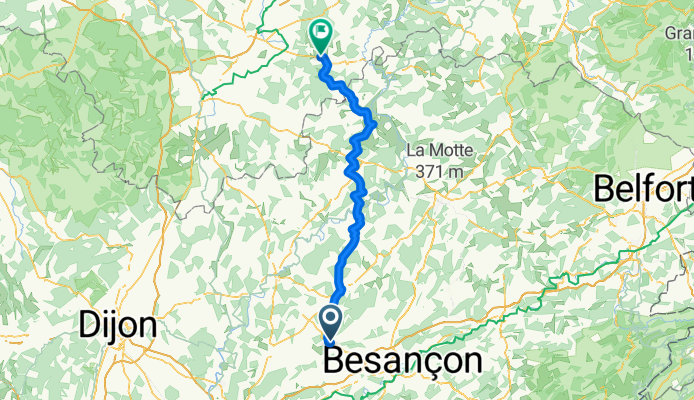
FA18Bourbonne
A cycling route starting in Marnay, Bourgogne-Franche-Comté, France.
Overview
About this route
- -:--
- Duration
- 104.1 km
- Distance
- 690 m
- Ascent
- 595 m
- Descent
- ---
- Avg. speed
- ---
- Avg. speed
Route quality
Waytypes & surfaces along the route
Waytypes
Road
40.4 km
(39 %)
Busy road
36.8 km
(35 %)
Surfaces
Paved
22.6 km
(22 %)
Asphalt
22.6 km
(22 %)
Undefined
81.4 km
(78 %)
Continue with Bikemap
Use, edit, or download this cycling route
You would like to ride FA18Bourbonne or customize it for your own trip? Here is what you can do with this Bikemap route:
Free features
- Save this route as favorite or in collections
- Copy & plan your own version of this route
- Sync your route with Garmin or Wahoo
Premium features
Free trial for 3 days, or one-time payment. More about Bikemap Premium.
- Navigate this route on iOS & Android
- Export a GPX / KML file of this route
- Create your custom printout (try it for free)
- Download this route for offline navigation
Discover more Premium features.
Get Bikemap PremiumFrom our community
Other popular routes starting in Marnay
- Etappe 7
- Distance
- 150.2 km
- Ascent
- 992 m
- Descent
- 883 m
- Location
- Marnay, Bourgogne-Franche-Comté, France
- 1a. De Groene Weg
- Distance
- 351 km
- Ascent
- 915 m
- Descent
- 944 m
- Location
- Marnay, Bourgogne-Franche-Comté, France
- Day 12: Marnay to Ornans
- Distance
- 55.1 km
- Ascent
- 613 m
- Descent
- 485 m
- Location
- Marnay, Bourgogne-Franche-Comté, France
- Groene route deel 2
- Distance
- 597.5 km
- Ascent
- 5,248 m
- Descent
- 5,440 m
- Location
- Marnay, Bourgogne-Franche-Comté, France
- FA18Bourbonne
- Distance
- 104.1 km
- Ascent
- 690 m
- Descent
- 595 m
- Location
- Marnay, Bourgogne-Franche-Comté, France
- Dag 1 Marnay Arbois Poligny
- Distance
- 64.9 km
- Ascent
- 570 m
- Descent
- 452 m
- Location
- Marnay, Bourgogne-Franche-Comté, France
- Der grüner Weg, Mitte und Süd
- Distance
- 692.1 km
- Ascent
- 1,417 m
- Descent
- 1,615 m
- Location
- Marnay, Bourgogne-Franche-Comté, France
- projet 263 route#2
- Distance
- 63.8 km
- Ascent
- 437 m
- Descent
- 431 m
- Location
- Marnay, Bourgogne-Franche-Comté, France
Open it in the app