
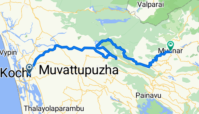
Kanayannur to Devikulam
A cycling route starting in Kumbalam, Kerala, India.
Overview
About this route
- 13 h 1 min
- Duration
- 175.2 km
- Distance
- 4,027 m
- Ascent
- 2,578 m
- Descent
- 13.5 km/h
- Avg. speed
- 1,686 m
- Avg. speed

Route quality
Waytypes & surfaces along the route
Waytypes
Quiet road
124.5 km
(71 %)
Road
35.4 km
(20 %)
Surfaces
Paved
24.4 km
(14 %)
Unpaved
8.2 km
(5 %)
Asphalt
21.4 km
(12 %)
Unpaved (undefined)
7.9 km
(4 %)
Continue with Bikemap
Use, edit, or download this cycling route
You would like to ride Kanayannur to Devikulam or customize it for your own trip? Here is what you can do with this Bikemap route:
Free features
- Save this route as favorite or in collections
- Copy & plan your own version of this route
- Sync your route with Garmin or Wahoo
Premium features
Free trial for 3 days, or one-time payment. More about Bikemap Premium.
- Navigate this route on iOS & Android
- Export a GPX / KML file of this route
- Create your custom printout (try it for free)
- Download this route for offline navigation
Discover more Premium features.
Get Bikemap PremiumFrom our community
Other popular routes starting in Kumbalam
 State Highway 15 29/1569, Kochi to Thuruthy Temple Road, Kochi
- Distance
- 16.3 km
- Ascent
- 21 m
- Descent
- 24 m
- Location
- Kumbalam, Kerala, India
 Kanayannur to Devikulam
- Distance
- 175.2 km
- Ascent
- 4,027 m
- Descent
- 2,578 m
- Location
- Kumbalam, Kerala, India
 Karath Road, Ernakulam to Banerji Road, Ernakulam
- Distance
- 13.8 km
- Ascent
- 83 m
- Descent
- 87 m
- Location
- Kumbalam, Kerala, India
 Brooks Bay Garden Road, Thrippunithura to 59C, Brooks Bay Garden Road, Thrippunithura
- Distance
- 23.6 km
- Ascent
- 3 m
- Descent
- 6 m
- Location
- Kumbalam, Kerala, India
 Thrippunithura, Kochi to Beach Link Road, Kochi
- Distance
- 25.5 km
- Ascent
- 166 m
- Descent
- 169 m
- Location
- Kumbalam, Kerala, India
 Quick ride through Kanayannur
- Distance
- 2.3 km
- Ascent
- 6 m
- Descent
- 8 m
- Location
- Kumbalam, Kerala, India
 KRPS-29, Kochi to KRPS-29, Kochi
- Distance
- 14.1 km
- Ascent
- 274 m
- Descent
- 277 m
- Location
- Kumbalam, Kerala, India
 X8CH+8HH, Ernakulam to X8CH+8C9, Ernakulam
- Distance
- 27.2 km
- Ascent
- 486 m
- Descent
- 400 m
- Location
- Kumbalam, Kerala, India
Open it in the app