

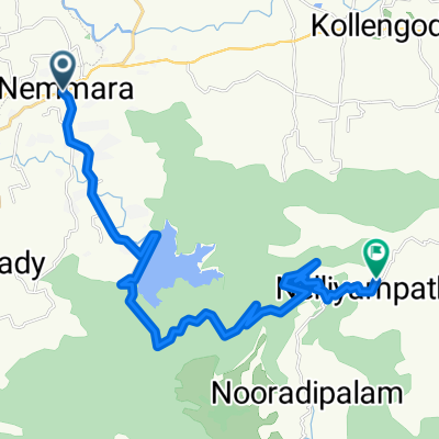
Route to Nelliyampathy Hills
A cycling route starting in Chittūr, Kerala, India.
Overview
About this route
- 1 h 51 min
- Duration
- 29.7 km
- Distance
- 1,708 m
- Ascent
- 804 m
- Descent
- 16 km/h
- Avg. speed
- 1,022 m
- Max. altitude

Route quality
Waytypes & surfaces along the route
Waytypes
Road
27 km
(91 %)
Access road
2.7 km
(9 %)
Continue with Bikemap
Use, edit, or download this cycling route
You would like to ride Route to Nelliyampathy Hills or customize it for your own trip? Here is what you can do with this Bikemap route:
Free features
- Save this route as favorite or in collections
- Copy & plan your own version of this route
- Sync your route with Garmin or Wahoo
Premium features
Free trial for 3 days, or one-time payment. More about Bikemap Premium.
- Navigate this route on iOS & Android
- Export a GPX / KML file of this route
- Create your custom printout (try it for free)
- Download this route for offline navigation
Discover more Premium features.
Get Bikemap PremiumFrom our community
Other popular routes starting in Chittūr
 Route to Nelliyampathy Hills
- Distance
- 29.7 km
- Ascent
- 1,708 m
- Descent
- 804 m
- Location
- Chittūr, Kerala, India
 home
home- Distance
- 5 km
- Ascent
- 144 m
- Descent
- 153 m
- Location
- Chittūr, Kerala, India
 MJ6V+XPP to Panchayat Road to Kudalloor
- Distance
- 8.5 km
- Ascent
- 53 m
- Descent
- 53 m
- Location
- Chittūr, Kerala, India
 Nallepilly Para Road to Nallepilly-Erattakulam Road
- Distance
- 141.9 km
- Ascent
- 2,482 m
- Descent
- 2,489 m
- Location
- Chittūr, Kerala, India
 Just for a RIDE
- Distance
- 140.4 km
- Ascent
- 455 m
- Descent
- 276 m
- Location
- Chittūr, Kerala, India
Open it in the app