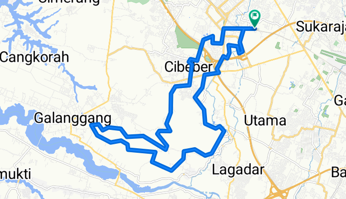
Gang Munajan 134, Kecamatan Cimahi Tengah to Gang Munajan 134, Kecamatan Cimahi Tengah
A cycling route starting in Cimahi, West Java, Indonesia.
Overview
About this route
- 2 h 10 min
- Duration
- 24.9 km
- Distance
- 353 m
- Ascent
- 351 m
- Descent
- 11.5 km/h
- Avg. speed
- 773 m
- Avg. speed
Route photos
Route quality
Waytypes & surfaces along the route
Waytypes
Quiet road
14.9 km
(60 %)
Road
3.4 km
(14 %)
Surfaces
Unpaved
0.3 km
(1 %)
Unpaved (undefined)
0.3 km
(1 %)
Undefined
24.6 km
(99 %)
Continue with Bikemap
Use, edit, or download this cycling route
You would like to ride Gang Munajan 134, Kecamatan Cimahi Tengah to Gang Munajan 134, Kecamatan Cimahi Tengah or customize it for your own trip? Here is what you can do with this Bikemap route:
Free features
- Save this route as favorite or in collections
- Copy & plan your own version of this route
- Sync your route with Garmin or Wahoo
Premium features
Free trial for 3 days, or one-time payment. More about Bikemap Premium.
- Navigate this route on iOS & Android
- Export a GPX / KML file of this route
- Create your custom printout (try it for free)
- Download this route for offline navigation
Discover more Premium features.
Get Bikemap PremiumFrom our community
Other popular routes starting in Cimahi
- Cimahi-Ciuyah-Cisarua-Situ Lembang
- Distance
- 15.6 km
- Ascent
- 816 m
- Descent
- 31 m
- Location
- Cimahi, West Java, Indonesia
- Jalan Nusantara Raya II 24, Kecamatan Ngamprah to Jalan Nusantara Raya II 24, Kecamatan Ngamprah
- Distance
- 4.2 km
- Ascent
- 42 m
- Descent
- 36 m
- Location
- Cimahi, West Java, Indonesia
- Pesantren - Kota Baru Parahyangan
- Distance
- 21.7 km
- Ascent
- 610 m
- Descent
- 646 m
- Location
- Cimahi, West Java, Indonesia
- Jalan Pinus Raya Barat 3, Kecamatan Parongpong to Jalan Puspa Kenanga Timur I 5a, Kecamatan Lembang
- Distance
- 6 km
- Ascent
- 357 m
- Descent
- 70 m
- Location
- Cimahi, West Java, Indonesia
- Batujajar - Tangkuban Parahu via Cihanjuang
- Distance
- 36.8 km
- Ascent
- 1,237 m
- Descent
- 412 m
- Location
- Cimahi, West Java, Indonesia
- Malela Loop BAJJ
- Distance
- 119.8 km
- Ascent
- 856 m
- Descent
- 856 m
- Location
- Cimahi, West Java, Indonesia
- Restful route
- Distance
- 13.7 km
- Ascent
- 47 m
- Descent
- 68 m
- Location
- Cimahi, West Java, Indonesia
- Gang Munajan 134, Kecamatan Cimahi Tengah to Gang Munajan 134, Kecamatan Cimahi Tengah
- Distance
- 24.9 km
- Ascent
- 353 m
- Descent
- 351 m
- Location
- Cimahi, West Java, Indonesia
Open it in the app