

Intermediate Sunday 3rd June 2012
A cycling route starting in Donegal, Ulster, Ireland.
Overview
About this route
Donegal Bay Cycling Club
Intermediate route Sunday 3rd June 2012
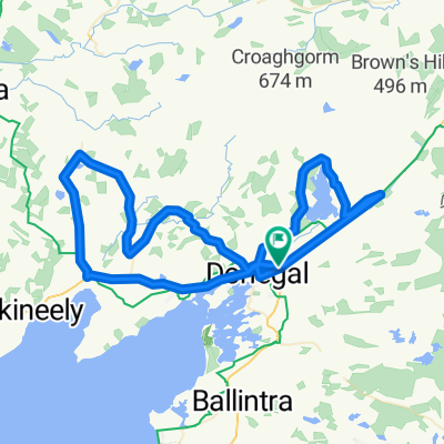
Start at Donegal Town Council Offices at 9am sharp
To Ballyshannon (turning left at Laghey to go along back road as far as Ballintra the on N15) then to Rossnowlagh rejoining the N15 at Ballintra. From there to Donegal Town (via the old road from Tullyearl roundabout, through the Diamond and then onto N56 at Macs Roundabout). Those wishing to return to the Council offices can do so at this stage.
Distance to this point is 30 miles (50km).
The route then heads towards Mountcharles pier (turning left off the N56 at the bottom of the Glen) and from there along the Dooring Line back to the N56 near Inver Bridge. From there it is back to the Council Offices in Donegal Town via the N56.
Total Distance 48 miles (80km)
- -:--
- Duration
- 76.9 km
- Distance
- 411 m
- Ascent
- 409 m
- Descent
- ---
- Avg. speed
- ---
- Max. altitude
Continue with Bikemap
Use, edit, or download this cycling route
You would like to ride Intermediate Sunday 3rd June 2012 or customize it for your own trip? Here is what you can do with this Bikemap route:
Free features
- Save this route as favorite or in collections
- Copy & plan your own version of this route
- Sync your route with Garmin or Wahoo
Premium features
Free trial for 3 days, or one-time payment. More about Bikemap Premium.
- Navigate this route on iOS & Android
- Export a GPX / KML file of this route
- Create your custom printout (try it for free)
- Download this route for offline navigation
Discover more Premium features.
Get Bikemap PremiumFrom our community
Other popular routes starting in Donegal
 Intermediate Sunday 3rd June 2012
- Distance
- 76.9 km
- Ascent
- 411 m
- Descent
- 409 m
- Location
- Donegal, Ulster, Ireland
 Intermediate Route Sunday 20th May 2012
- Distance
- 73.6 km
- Ascent
- 546 m
- Descent
- 546 m
- Location
- Donegal, Ulster, Ireland
 Donegal - Ballybofey
- Distance
- 58.3 km
- Ascent
- 621 m
- Descent
- 546 m
- Location
- Donegal, Ulster, Ireland
 Donegal_Lisnarick_Camping_Castle_Dia5_parte2
- Distance
- 39.6 km
- Ascent
- 265 m
- Descent
- 222 m
- Location
- Donegal, Ulster, Ireland
 TOI May 23 Day 4
- Distance
- 71 km
- Ascent
- 609 m
- Descent
- 611 m
- Location
- Donegal, Ulster, Ireland
 DBCC Intermediate Run 11/03/2012
- Distance
- 46.9 km
- Ascent
- 352 m
- Descent
- 352 m
- Location
- Donegal, Ulster, Ireland
 Donegal - Letterkenny
- Distance
- 56.9 km
- Ascent
- 683 m
- Descent
- 686 m
- Location
- Donegal, Ulster, Ireland
 Dongegal Runde
- Distance
- 224.1 km
- Ascent
- 1,069 m
- Descent
- 1,070 m
- Location
- Donegal, Ulster, Ireland
Open it in the app