

2025 Romanja
2025 Ptujska Gora Celotna trasa (Žiri - Moravče - Trojane - Velenje)
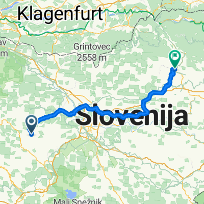
A cycling route starting in Žiri, Občina Žiri, Slovenia.
Overview
About this route
opis: Statistika je izračunana na podlagi uvoženih podatkovRazdalja: 129,1 kmNajmanjša nadmorska višina: 283 mNajvečja nadmorska višina: 532 mSkupni vzpon: 1014 mSkupni spust: 1094 mDatum: 25.07.2025Razdalja (km): 129Skupni vzpon (v.m.): 1015Skupni spust (v.m.): 1095
- 13 h 44 min
- Duration
- 202.1 km
- Distance
- 2,910 m
- Ascent
- 3,056 m
- Descent
- 14.7 km/h
- Avg. speed
- 677 m
- Max. altitude

Part of
8 stages
Route quality
Waytypes & surfaces along the route
Waytypes
Quiet road
44.5 km
(22 %)
Road
28.3 km
(14 %)
Surfaces
Paved
127.3 km
(63 %)
Asphalt
127.3 km
(63 %)
Undefined
74.8 km
(37 %)
Continue with Bikemap
Use, edit, or download this cycling route
You would like to ride 2025 Ptujska Gora Celotna trasa (Žiri - Moravče - Trojane - Velenje) or customize it for your own trip? Here is what you can do with this Bikemap route:
Free features
- Save this route as favorite or in collections
- Copy & plan your own version of this route
- Split it into stages to create a multi-day tour
- Sync your route with Garmin or Wahoo
Premium features
Free trial for 3 days, or one-time payment. More about Bikemap Premium.
- Navigate this route on iOS & Android
- Export a GPX / KML file of this route
- Create your custom printout (try it for free)
- Download this route for offline navigation
Discover more Premium features.
Get Bikemap PremiumFrom our community
Other popular routes starting in Žiri
 Na pasjo Pavan-čez Mrzli vrh
- Distance
- 68.4 km
- Ascent
- 1,206 m
- Descent
- 1,206 m
- Location
- Žiri, Občina Žiri, Slovenia
 2025 Ptujska Gora 1. dan (Žiri - Moravče - Trojane - Velenje)
- Distance
- 129 km
- Ascent
- 1,954 m
- Descent
- 2,032 m
- Location
- Žiri, Občina Žiri, Slovenia
 2014 Dunaj
- Distance
- 473.7 km
- Ascent
- 2,323 m
- Descent
- 2,609 m
- Location
- Žiri, Občina Žiri, Slovenia
 2024 Žeželj pri Vinici 1. dan (Žiri - Kočevje)
- Distance
- 97.1 km
- Ascent
- 1,379 m
- Descent
- 1,393 m
- Location
- Žiri, Občina Žiri, Slovenia
 Rovte
Rovte- Distance
- 28.2 km
- Ascent
- 654 m
- Descent
- 651 m
- Location
- Žiri, Občina Žiri, Slovenia
 2023 Romanja Sveta Gora
- Distance
- 94.6 km
- Ascent
- 2,127 m
- Descent
- 1,931 m
- Location
- Žiri, Občina Žiri, Slovenia
 morje
morje- Distance
- 125.2 km
- Ascent
- 828 m
- Descent
- 1,300 m
- Location
- Žiri, Občina Žiri, Slovenia
 Rovte - Ajdovščina - Izola
- Distance
- 142.8 km
- Ascent
- 972 m
- Descent
- 1,665 m
- Location
- Žiri, Občina Žiri, Slovenia
Open it in the app