
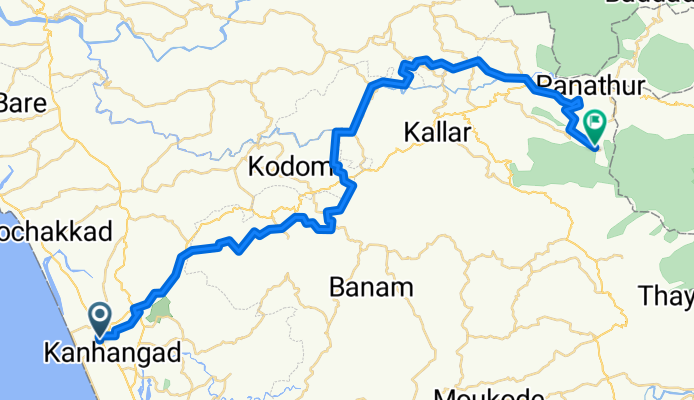
Route to Ranipuram
A cycling route starting in Kanhangad, Kerala, India.
Overview
About this route
- 4 h 58 min
- Duration
- 58.6 km
- Distance
- 2,397 m
- Ascent
- 1,719 m
- Descent
- 11.8 km/h
- Avg. speed
- 711 m
- Max. altitude

Route quality
Waytypes & surfaces along the route
Waytypes
Quiet road
33.7 km
(57 %)
Road
13.8 km
(24 %)
Surfaces
Paved
7 km
(12 %)
Unpaved
1 km
(2 %)
Asphalt
6.6 km
(11 %)
Unpaved (undefined)
0.6 km
(<1 %)
Continue with Bikemap
Use, edit, or download this cycling route
You would like to ride Route to Ranipuram or customize it for your own trip? Here is what you can do with this Bikemap route:
Free features
- Save this route as favorite or in collections
- Copy & plan your own version of this route
- Sync your route with Garmin or Wahoo
Premium features
Free trial for 3 days, or one-time payment. More about Bikemap Premium.
- Navigate this route on iOS & Android
- Export a GPX / KML file of this route
- Create your custom printout (try it for free)
- Download this route for offline navigation
Discover more Premium features.
Get Bikemap PremiumFrom our community
Other popular routes starting in Kanhangad
 121015 - Puttur
- Distance
- 80.9 km
- Ascent
- 635 m
- Descent
- 560 m
- Location
- Kanhangad, Kerala, India
 845G+JPM, Kasaragod to 74MW+HHC, Kakkat
- Distance
- 5.4 km
- Ascent
- 63 m
- Descent
- 42 m
- Location
- Kanhangad, Kerala, India
 All kerala ride
- Distance
- 514.2 km
- Ascent
- 1,294 m
- Descent
- 1,306 m
- Location
- Kanhangad, Kerala, India
 Kalluravi Road, Kanhangad to Departure Road, Mattannur
- Distance
- 86.4 km
- Ascent
- 577 m
- Descent
- 505 m
- Location
- Kanhangad, Kerala, India
 nileshwaram route
- Distance
- 13.2 km
- Ascent
- 33 m
- Descent
- 33 m
- Location
- Kanhangad, Kerala, India
 Route from South School Road, Kanhangad
- Distance
- 27.8 km
- Ascent
- 189 m
- Descent
- 186 m
- Location
- Kanhangad, Kerala, India
 kanganhad trip
- Distance
- 18.2 km
- Ascent
- 124 m
- Descent
- 122 m
- Location
- Kanhangad, Kerala, India
 Pullur - Pannikkunnu Road to Kanhangad - Rajapuram - Malom Road
- Distance
- 40.3 km
- Ascent
- 758 m
- Descent
- 339 m
- Location
- Kanhangad, Kerala, India
Open it in the app