

Sieglitzberger Runde
A cycling route starting in Schnaittach, Bavaria, Germany.
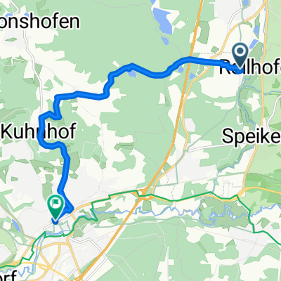
Overview
About this route
Mountainous, Roads, forest paths and woodland trails beautiful landscapes
- -:--
- Duration
- 36.4 km
- Distance
- 659 m
- Ascent
- 657 m
- Descent
- ---
- Avg. speed
- ---
- Max. altitude
Route quality
Waytypes & surfaces along the route
Waytypes
Quiet road
21.1 km
(58 %)
Track
12.7 km
(35 %)
Surfaces
Paved
12.4 km
(34 %)
Unpaved
10.5 km
(29 %)
Asphalt
9.8 km
(27 %)
Gravel
6.9 km
(19 %)
Continue with Bikemap
Use, edit, or download this cycling route
You would like to ride Sieglitzberger Runde or customize it for your own trip? Here is what you can do with this Bikemap route:
Free features
- Save this route as favorite or in collections
- Copy & plan your own version of this route
- Sync your route with Garmin or Wahoo
Premium features
Free trial for 3 days, or one-time payment. More about Bikemap Premium.
- Navigate this route on iOS & Android
- Export a GPX / KML file of this route
- Create your custom printout (try it for free)
- Download this route for offline navigation
Discover more Premium features.
Get Bikemap PremiumFrom our community
Other popular routes starting in Schnaittach
 Radelparadies Nürnberger Land: Tour 1
- Distance
- 40.4 km
- Ascent
- 339 m
- Descent
- 339 m
- Location
- Schnaittach, Bavaria, Germany
 Schnaittach - Hohenstein - Schnaittach
- Distance
- 29.9 km
- Ascent
- 701 m
- Descent
- 693 m
- Location
- Schnaittach, Bavaria, Germany
 Sieglitzberger Runde
- Distance
- 36.4 km
- Ascent
- 659 m
- Descent
- 657 m
- Location
- Schnaittach, Bavaria, Germany
 Rollhofen - Dehnberg - Lauf
- Distance
- 9.3 km
- Ascent
- 168 m
- Descent
- 181 m
- Location
- Schnaittach, Bavaria, Germany
 Frankenalp 3
- Distance
- 23.1 km
- Ascent
- 371 m
- Descent
- 364 m
- Location
- Schnaittach, Bavaria, Germany
 20. Mittelfrankencup 2012 Ausfahrt 03 am 20.05.2012 in Schnaittach
- Distance
- 153 km
- Ascent
- 985 m
- Descent
- 985 m
- Location
- Schnaittach, Bavaria, Germany
 Schnaittach-Vorra-Schnaittach
- Distance
- 39.6 km
- Ascent
- 785 m
- Descent
- 906 m
- Location
- Schnaittach, Bavaria, Germany
 Fritz-Schnelbögl-Straße 14, Schnaittach nach Amag-Hilpert-Straße 20, Pegnitz
- Distance
- 34.5 km
- Ascent
- 415 m
- Descent
- 345 m
- Location
- Schnaittach, Bavaria, Germany
Open it in the app