

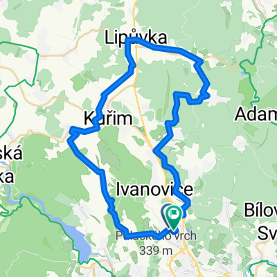
Brno - Útěchov - Olomučany - Olešná - Brno
A cycling route starting in Mokrá Hora, South Moravian, Czechia.
Overview
About this route
sice ne tak dlouhá, ale poměrně náročná kopcovitá trasa (dle tachometru nastoupáno cca 950 m)<br />
na trase je několik stoupání odpovídajících 3. a 4. kategorii dle TDF<br />
kopec v úseku mezi Olomučany a Klepáčovem je stojka o sklonu až 17%<br />
- -:--
- Duration
- 52.2 km
- Distance
- 814 m
- Ascent
- 814 m
- Descent
- ---
- Avg. speed
- ---
- Max. altitude
Route quality
Waytypes & surfaces along the route
Waytypes
Road
35.5 km
(68 %)
Quiet road
11 km
(21 %)
Surfaces
Paved
45.9 km
(88 %)
Asphalt
45.4 km
(87 %)
Concrete
0.5 km
(1 %)
Undefined
6.3 km
(12 %)
Route highlights
Points of interest along the route
Point of interest after 9.7 km
horská prémie 3. kategorie
Point of interest after 25.5 km
horská prémie 4. kategorie
Point of interest after 34.9 km
horská prémie 4. kategorie
Point of interest after 40.9 km
horská prémie 4. kategorie
Continue with Bikemap
Use, edit, or download this cycling route
You would like to ride Brno - Útěchov - Olomučany - Olešná - Brno or customize it for your own trip? Here is what you can do with this Bikemap route:
Free features
- Save this route as favorite or in collections
- Copy & plan your own version of this route
- Sync your route with Garmin or Wahoo
Premium features
Free trial for 3 days, or one-time payment. More about Bikemap Premium.
- Navigate this route on iOS & Android
- Export a GPX / KML file of this route
- Create your custom printout (try it for free)
- Download this route for offline navigation
Discover more Premium features.
Get Bikemap PremiumFrom our community
Other popular routes starting in Mokrá Hora
 Medlanky_NoveNam_KyselaHora_nadLesnou_Obrany_Svitava_PFC
- Distance
- 15.7 km
- Ascent
- 208 m
- Descent
- 221 m
- Location
- Mokrá Hora, South Moravian, Czechia
 Na nedělní odpoledne
- Distance
- 37 km
- Ascent
- 599 m
- Descent
- 600 m
- Location
- Mokrá Hora, South Moravian, Czechia
 Brno - Útěchov - Olomučany - Olešná - Brno
- Distance
- 52.2 km
- Ascent
- 814 m
- Descent
- 814 m
- Location
- Mokrá Hora, South Moravian, Czechia
 Vranov
- Distance
- 22.7 km
- Ascent
- 456 m
- Descent
- 442 m
- Location
- Mokrá Hora, South Moravian, Czechia
 Route in Brno
- Distance
- 40.3 km
- Ascent
- 760 m
- Descent
- 760 m
- Location
- Mokrá Hora, South Moravian, Czechia
 34 km - Okolo Prýglu L-P
- Distance
- 33.5 km
- Ascent
- 425 m
- Descent
- 425 m
- Location
- Mokrá Hora, South Moravian, Czechia
 Brno_Babylon_77_1630
- Distance
- 76.9 km
- Ascent
- 1,744 m
- Descent
- 1,744 m
- Location
- Mokrá Hora, South Moravian, Czechia
 Brněnské kolečko
- Distance
- 90.6 km
- Ascent
- 735 m
- Descent
- 734 m
- Location
- Mokrá Hora, South Moravian, Czechia
Open it in the app