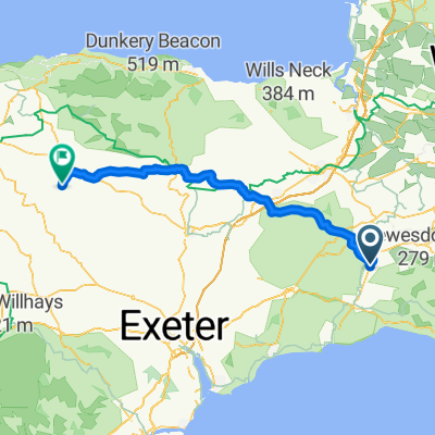
1hr20 Chard reservoir - the return
A cycling route starting in Chard, England, United Kingdom.
Overview
About this route
- 41 min
- Duration
- 14 km
- Distance
- 182 m
- Ascent
- 208 m
- Descent
- 20.4 km/h
- Avg. speed
- 148 m
- Avg. speed
Route quality
Waytypes & surfaces along the route
Waytypes
Quiet road
13.3 km
(95 %)
Road
0.7 km
(5 %)
Undefined
-0 km
(<1 %)
Surfaces
Paved
2 km
(14 %)
Asphalt
2 km
(14 %)
Undefined
12 km
(86 %)
Continue with Bikemap
Use, edit, or download this cycling route
You would like to ride 1hr20 Chard reservoir - the return or customize it for your own trip? Here is what you can do with this Bikemap route:
Free features
- Save this route as favorite or in collections
- Copy & plan your own version of this route
- Sync your route with Garmin or Wahoo
Premium features
Free trial for 3 days, or one-time payment. More about Bikemap Premium.
- Navigate this route on iOS & Android
- Export a GPX / KML file of this route
- Create your custom printout (try it for free)
- Download this route for offline navigation
Discover more Premium features.
Get Bikemap PremiumFrom our community
Other popular routes starting in Chard
- Chard to Burrowbridge
- Distance
- 42.5 km
- Ascent
- 221 m
- Descent
- 311 m
- Location
- Chard, England, United Kingdom
- Tatworth Circle via Thorncombe Long Route
- Distance
- 21.3 km
- Ascent
- 344 m
- Descent
- 344 m
- Location
- Chard, England, United Kingdom
- Chard back
- Distance
- 45.3 km
- Ascent
- 329 m
- Descent
- 429 m
- Location
- Chard, England, United Kingdom
- Chardstock Com Hall to Broad Windsor
- Distance
- 47.4 km
- Ascent
- 820 m
- Descent
- 817 m
- Location
- Chard, England, United Kingdom
- Route from Balsom Close, Chard
- Distance
- 11.5 km
- Ascent
- 0 m
- Descent
- 11 m
- Location
- Chard, England, United Kingdom
- coast run
- Distance
- 117.9 km
- Ascent
- 1,213 m
- Descent
- 1,213 m
- Location
- Chard, England, United Kingdom
- Chard to Stoke St Mary
- Distance
- 36.1 km
- Ascent
- 309 m
- Descent
- 403 m
- Location
- Chard, England, United Kingdom
- South Somerset route
- Distance
- 125 km
- Ascent
- 509 m
- Descent
- 509 m
- Location
- Chard, England, United Kingdom
Open it in the app