
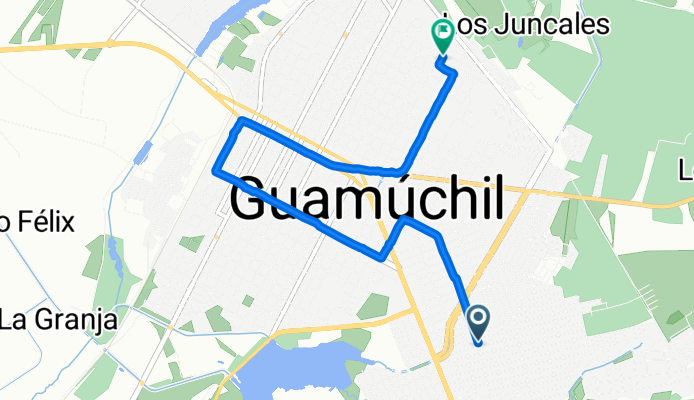
25.447, -108.066 a 25.469, -108.069
A cycling route starting in Guamúchil, Sinaloa, Mexico.
Overview
About this route
- 20 min
- Duration
- 6.5 km
- Distance
- 61 m
- Ascent
- 63 m
- Descent
- 20 km/h
- Avg. speed
- 66 m
- Max. altitude

Continue with Bikemap
Use, edit, or download this cycling route
You would like to ride 25.447, -108.066 a 25.469, -108.069 or customize it for your own trip? Here is what you can do with this Bikemap route:
Free features
- Save this route as favorite or in collections
- Copy & plan your own version of this route
- Sync your route with Garmin or Wahoo
Premium features
Free trial for 3 days, or one-time payment. More about Bikemap Premium.
- Navigate this route on iOS & Android
- Export a GPX / KML file of this route
- Create your custom printout (try it for free)
- Download this route for offline navigation
Discover more Premium features.
Get Bikemap PremiumFrom our community
Other popular routes starting in Guamúchil
 De Gabriel Leyva Solano 1629, Guamúchil a Avenida Álamos 1329, Guamúchil
- Distance
- 160 km
- Ascent
- 1,167 m
- Descent
- 1,171 m
- Location
- Guamúchil, Sinaloa, Mexico
 Calle Ramón Cervantes León 92–94, Benito Juárez a Avenida Ignacio Zaragoza 20, Benito Juárez
- Distance
- 3.6 km
- Ascent
- 3 m
- Descent
- 3 m
- Location
- Guamúchil, Sinaloa, Mexico
 De Plan de Ayala 725, Guamúchil a Bahía de San Esteban 148, Guamúchil
- Distance
- 3.3 km
- Ascent
- 54 m
- Descent
- 49 m
- Location
- Guamúchil, Sinaloa, Mexico
 Avenida Venustiano Carranza 823–849, Guamúchil a Calle Felipe Ángeles 99, Guamúchil
- Distance
- 6.8 km
- Ascent
- 38 m
- Descent
- 38 m
- Location
- Guamúchil, Sinaloa, Mexico
 De Calle Netzahualcóyotl 309–331, Guamúchil a Calle Netzahualcóyotl 309–331, Guamúchil
- Distance
- 9.4 km
- Ascent
- 55 m
- Descent
- 59 m
- Location
- Guamúchil, Sinaloa, Mexico
 ruta la presa, letras y matamoros
- Distance
- 9.2 km
- Ascent
- 13 m
- Descent
- 32 m
- Location
- Guamúchil, Sinaloa, Mexico
 25.468, -108.068 a 25.446, -108.067
- Distance
- 3.3 km
- Ascent
- 21 m
- Descent
- 16 m
- Location
- Guamúchil, Sinaloa, Mexico
 Avenida Mariano Matamoros Norte, Guamúchil a Avenida Mariano Matamoros Norte, Guamúchil
- Distance
- 4.8 km
- Ascent
- 69 m
- Descent
- 51 m
- Location
- Guamúchil, Sinaloa, Mexico
Open it in the app