RR Rheinstetten - Hornisgrinde und zurück
A cycling route starting in Neuburg, Rhineland-Palatinate, Germany.
Overview
About this route
A route of the RadSportSenioren Rheinstetten.
Ridden on 30.05.2012 by Peter, Martin and Jürgen.
Route was recorded and transferred here.
Measured values: 143Km; 1268Hm
- -:--
- Duration
- 140.2 km
- Distance
- 1,124 m
- Ascent
- 1,124 m
- Descent
- ---
- Avg. speed
- ---
- Max. altitude
Route quality
Waytypes & surfaces along the route
Waytypes
Track
35 km
(25 %)
Road
25.2 km
(18 %)
Surfaces
Paved
124.8 km
(89 %)
Unpaved
4.2 km
(3 %)
Asphalt
117.8 km
(84 %)
Paved (undefined)
7 km
(5 %)
Route highlights
Points of interest along the route
Point of interest after 66.1 km
Verpflegungsstelle Seibelseckle. Besonders zu empfehlen: Heidelbeerkuchen
Point of interest after 68.3 km
Es lohnt sich am Mummelsee die Straße hoch zum alten Turm zu fahren. Die Aussicht ist grandios. Es besteht die Möglichkeit über einen Wanderweg (Schiebestrecke von 500m für das RR) zum Sendeturm zu gehen. Ab hier fahren sie wieder auf Asphalt.
Continue with Bikemap
Use, edit, or download this cycling route
You would like to ride RR Rheinstetten - Hornisgrinde und zurück or customize it for your own trip? Here is what you can do with this Bikemap route:
Free features
- Save this route as favorite or in collections
- Copy & plan your own version of this route
- Split it into stages to create a multi-day tour
- Sync your route with Garmin or Wahoo
Premium features
Free trial for 3 days, or one-time payment. More about Bikemap Premium.
- Navigate this route on iOS & Android
- Export a GPX / KML file of this route
- Create your custom printout (try it for free)
- Download this route for offline navigation
Discover more Premium features.
Get Bikemap PremiumFrom our community
Other popular routes starting in Neuburg
MB aus Rheinstetten auf dem G.Rhenaweg nach Herrenalb über den Reiterweg nach Zieflensberg zur Talwiese über den Achtlersweg zur Hahnenfalzhütte- und Kreuzlehüt- Distance
- 101.7 km
- Ascent
- 1,160 m
- Descent
- 1,164 m
- Location
- Neuburg, Rhineland-Palatinate, Germany
RR Rheinstetten - Hornisgrinde und zurück- Distance
- 140.2 km
- Ascent
- 1,124 m
- Descent
- 1,124 m
- Location
- Neuburg, Rhineland-Palatinate, Germany
RLP1: Neuburg a. Rhein - Eppenbrunn 71,3km 396hm- Distance
- 71.3 km
- Ascent
- 402 m
- Descent
- 232 m
- Location
- Neuburg, Rhineland-Palatinate, Germany
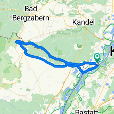
MB Rund-Route Rheinstetten - Graf Rhenaweg - Herrenalb - Gaistal- Distance
- 104.5 km
- Ascent
- 1,034 m
- Descent
- 1,034 m
- Location
- Neuburg, Rhineland-Palatinate, Germany
auf Radwegen durch die lieblichen Dörfer der Südpfalz ins leicht hügelige und kurvenreiche Nordelsaß mit seinen Fachwerkdörfern.- Distance
- 88.2 km
- Ascent
- 221 m
- Descent
- 223 m
- Location
- Neuburg, Rhineland-Palatinate, Germany
Bienwaldtour20210227- Distance
- 35.7 km
- Ascent
- 36 m
- Descent
- 39 m
- Location
- Neuburg, Rhineland-Palatinate, Germany
FR1 1: Neuburg a. Rhein - Eppenbrunn 71,6km 560hm- Distance
- 71.6 km
- Ascent
- 783 m
- Descent
- 615 m
- Location
- Neuburg, Rhineland-Palatinate, Germany
Rechts und links des Rheins- Distance
- 54.2 km
- Ascent
- 35 m
- Descent
- 32 m
- Location
- Neuburg, Rhineland-Palatinate, Germany
Open it in the app


