

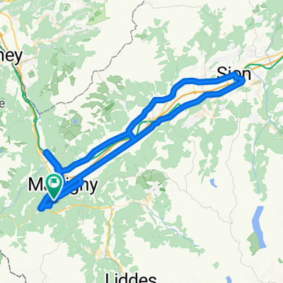
Champex and Val Ferret
A cycling route starting in Martigny-Combe, Valais, Switzerland.
Overview
About this route
- -:--
- Duration
- 62.9 km
- Distance
- 1,722 m
- Ascent
- 1,722 m
- Descent
- ---
- Avg. speed
- ---
- Max. altitude

Route quality
Waytypes & surfaces along the route
Waytypes
Road
37.1 km
(59 %)
Quiet road
6.3 km
(10 %)
Surfaces
Paved
17.6 km
(28 %)
Asphalt
17.6 km
(28 %)
Undefined
45.3 km
(72 %)
Route highlights
Points of interest along the route
Point of interest after 34.2 km
Val Ferret - end of paved road
Continue with Bikemap
Use, edit, or download this cycling route
You would like to ride Champex and Val Ferret or customize it for your own trip? Here is what you can do with this Bikemap route:
Free features
- Save this route as favorite or in collections
- Copy & plan your own version of this route
- Sync your route with Garmin or Wahoo
Premium features
Free trial for 3 days, or one-time payment. More about Bikemap Premium.
- Navigate this route on iOS & Android
- Export a GPX / KML file of this route
- Create your custom printout (try it for free)
- Download this route for offline navigation
Discover more Premium features.
Get Bikemap PremiumFrom our community
Other popular routes starting in Martigny-Combe
 Route de la Forclaz, Martigny-Croix nach Chemin du Glacier de Taconnaz, Chamonix-Mont-Blanc
- Distance
- 35.6 km
- Ascent
- 658 m
- Descent
- 964 m
- Location
- Martigny-Combe, Valais, Switzerland
 VTT MONT BLANC Vllorcine Albertville
- Distance
- 432.8 km
- Ascent
- 8,172 m
- Descent
- 8,462 m
- Location
- Martigny-Combe, Valais, Switzerland
 Trevor Flat big loop
- Distance
- 73.5 km
- Ascent
- 303 m
- Descent
- 303 m
- Location
- Martigny-Combe, Valais, Switzerland
 Startup Route des Grandes Alpes
- Distance
- 40 km
- Ascent
- 1,360 m
- Descent
- 834 m
- Location
- Martigny-Combe, Valais, Switzerland
 La Chatelard-Lac de Emosson
- Distance
- 18.3 km
- Ascent
- 1,556 m
- Descent
- 838 m
- Location
- Martigny-Combe, Valais, Switzerland
 2017 ALPS Etapa 7 - Le Grand St Bernanrd
- Distance
- 108.8 km
- Ascent
- 2,888 m
- Descent
- 2,896 m
- Location
- Martigny-Combe, Valais, Switzerland
 Trevor Base Route
- Distance
- 93.3 km
- Ascent
- 715 m
- Descent
- 715 m
- Location
- Martigny-Combe, Valais, Switzerland
 Trevor - Champex and Planche
- Distance
- 51.3 km
- Ascent
- 1,740 m
- Descent
- 1,740 m
- Location
- Martigny-Combe, Valais, Switzerland
Open it in the app