
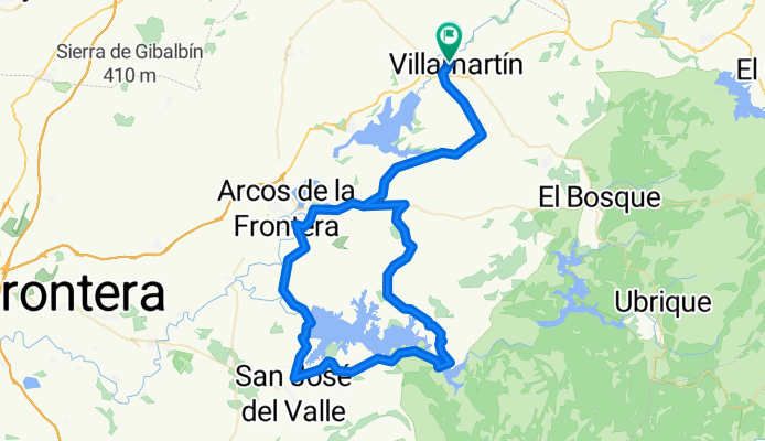
Villamartín-San José del Valle-Algar-Bda. La Perdíz-Villamartín
A cycling route starting in Villamartín, Andalusia, Spain.
Overview
About this route
Stage that circles the entire Guadalcacín reservoir. Quiet road with beautiful scenery. The section from Arcos de la Frontera to the dam is a narrow road and somewhat busier than other routes with similar roads. Highlight is the climb to Algar from the tail of the reservoir. The route can be extended by returning via Prado del Rey.
- -:--
- Duration
- 103.6 km
- Distance
- 765 m
- Ascent
- 759 m
- Descent
- ---
- Avg. speed
- ---
- Max. altitude

Continue with Bikemap
Use, edit, or download this cycling route
You would like to ride Villamartín-San José del Valle-Algar-Bda. La Perdíz-Villamartín or customize it for your own trip? Here is what you can do with this Bikemap route:
Free features
- Save this route as favorite or in collections
- Copy & plan your own version of this route
- Split it into stages to create a multi-day tour
- Sync your route with Garmin or Wahoo
Premium features
Free trial for 3 days, or one-time payment. More about Bikemap Premium.
- Navigate this route on iOS & Android
- Export a GPX / KML file of this route
- Create your custom printout (try it for free)
- Download this route for offline navigation
Discover more Premium features.
Get Bikemap PremiumFrom our community
Other popular routes starting in Villamartín
 Villamartín-Gibalbín-Circuito de velocidad- La Barca de la Florida- La Ina-Carretera El Portal-Puerto Real
- Distance
- 125 km
- Ascent
- 565 m
- Descent
- 672 m
- Location
- Villamartín, Andalusia, Spain
 Villamartín-Prado del Rey-Venta Mariquita-Regantío-Villamartín
- Distance
- 57.1 km
- Ascent
- 527 m
- Descent
- 519 m
- Location
- Villamartín, Andalusia, Spain
 Villamartín-Prado del Rey-Zahara-Las Palomas-El Boyar-El Bosque-Prado del Rey-Villamartín
- Distance
- 89.6 km
- Ascent
- 1,470 m
- Descent
- 1,462 m
- Location
- Villamartín, Andalusia, Spain
 Villamartin - San José del Valle
- Distance
- 56.5 km
- Ascent
- 325 m
- Descent
- 302 m
- Location
- Villamartín, Andalusia, Spain
 Villamartín - Los Pozos - Bda Fátima - Villamartín
- Distance
- 60.1 km
- Ascent
- 417 m
- Descent
- 385 m
- Location
- Villamartín, Andalusia, Spain
 Villamartin - El Bosque por la Ventolera
- Distance
- 52.4 km
- Ascent
- 704 m
- Descent
- 704 m
- Location
- Villamartín, Andalusia, Spain
 Villamartín-San José del Valle-Algar-Bda. La Perdíz-Villamartín
- Distance
- 103.6 km
- Ascent
- 765 m
- Descent
- 759 m
- Location
- Villamartín, Andalusia, Spain
 Villamartín - Las Abiertas - Presa Bornos - Bornos - Villamartin
- Distance
- 62.7 km
- Ascent
- 443 m
- Descent
- 443 m
- Location
- Villamartín, Andalusia, Spain
Open it in the app