Německo 2012-2.den-Bernstein-Pramen Weisser Main
A cycling route starting in Höchstädt bei Thiersheim, Bavaria, Germany.
Overview
About this route
2nd day of the route 25.05.2012, the destination is spring of the Weisser Main.
I am still following the Fichtelgebirgs-Radweg.
At the crossroads Rudolfsattel 830m there is a beautiful stone rest area and after that ascent, a well-deserved rest. At the slopes of this hill, the springs RöslaQuelle, EgerQuelle, SaaleQuelle, FichtelnaabQuelle and WeiSmainQuelle.
I stick to the first sign to the WeiSmainquelle (even though certain sections are for pedestrians - I have no idea how steep that climb will be) up to the spring.
Again without a map and exploring little towns, I rode: 26.5km
Bernstein - Schonlind - Röslau - Bödlas - Birk - crossroads Rudolfsattel - pond Karchessee - spring of the Main
- -:--
- Duration
- 26.3 km
- Distance
- 622 m
- Ascent
- 370 m
- Descent
- ---
- Avg. speed
- ---
- Max. altitude
Route quality
Waytypes & surfaces along the route
Waytypes
Track
13.7 km
(52 %)
Quiet road
6.8 km
(26 %)
Surfaces
Paved
3.2 km
(12 %)
Unpaved
13.4 km
(51 %)
Gravel
8.9 km
(34 %)
Ground
2.6 km
(10 %)
Route highlights
Points of interest along the route

Photo after 0 km
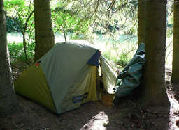
1.nocleh

Photo after 2.1 km
Info mapa

Point of interest after 10.4 km
Voda

Point of interest after 16.4 km
Voda, tak vařím kávičku

Photo after 17.3 km
Lavička k odpočinku

Photo after 19.1 km
odtud jsem přijela

Photo after 19.1 km
pro pěší

Photo after 19.1 km

Photo after 19.1 km
rozcestí Rudolfsattel 830 m

Photo after 19.1 km
pro pěší

Photo after 19.2 km

Photo after 19.2 km
tudy já

Photo after 19.7 km
rozcestí

Photo after 20.8 km
rozcestí 4 pramenů

Photo after 22.1 km
pro pěší

Photo after 24.4 km
za silnicí

Photo after 24.9 km
část dneška

Photo after 26.3 km
pramen Mainu

Photo after 26.3 km
info mapa řeky Main

Photo after 26.3 km
2. nocleh
Continue with Bikemap
Use, edit, or download this cycling route
You would like to ride Německo 2012-2.den-Bernstein-Pramen Weisser Main or customize it for your own trip? Here is what you can do with this Bikemap route:
Free features
- Save this route as favorite or in collections
- Copy & plan your own version of this route
- Sync your route with Garmin or Wahoo
Premium features
Free trial for 3 days, or one-time payment. More about Bikemap Premium.
- Navigate this route on iOS & Android
- Export a GPX / KML file of this route
- Create your custom printout (try it for free)
- Download this route for offline navigation
Discover more Premium features.
Get Bikemap PremiumFrom our community
Other popular routes starting in Höchstädt bei Thiersheim
 Radweg Nachtberg
- Distance
- 11.4 km
- Ascent
- 160 m
- Descent
- 158 m
- Location
- Höchstädt bei Thiersheim, Bavaria, Germany
 Höchstädt - Aš
- Distance
- 24.8 km
- Ascent
- 269 m
- Descent
- 195 m
- Location
- Höchstädt bei Thiersheim, Bavaria, Germany
 Nachtbergrunde
- Distance
- 7.5 km
- Ascent
- 118 m
- Descent
- 115 m
- Location
- Höchstädt bei Thiersheim, Bavaria, Germany
 Německo 2012-2.den-Bernstein-Pramen Weisser Main
- Distance
- 26.3 km
- Ascent
- 622 m
- Descent
- 370 m
- Location
- Höchstädt bei Thiersheim, Bavaria, Germany
 Laufrunde extended
- Distance
- 12.7 km
- Ascent
- 129 m
- Descent
- 126 m
- Location
- Höchstädt bei Thiersheim, Bavaria, Germany
 Radweg Rundfahrt
- Distance
- 62.6 km
- Ascent
- 421 m
- Descent
- 418 m
- Location
- Höchstädt bei Thiersheim, Bavaria, Germany
 Burg Hohenberg
- Distance
- 13.3 km
- Ascent
- 107 m
- Descent
- 209 m
- Location
- Höchstädt bei Thiersheim, Bavaria, Germany
 Radsporttag Höchstädt
- Distance
- 105 km
- Ascent
- 825 m
- Descent
- 825 m
- Location
- Höchstädt bei Thiersheim, Bavaria, Germany
Open it in the app


